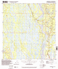
1994 Map of Talkeetna A-1
USGS Topo · Published 2002About this map
The Susitna River dominates the eastern corridor of this landscape, its wide braided channels and the Birch Creek Slough defining the local hydrology near the junction of the George Parks Highway and Talkeetna Road. This 1994 survey captures the region's transport evolution, where modern pavement meets the historical Winter Trail and various 4wd tracks that reach into the interior. Local nomenclature provides a sense of the surveying era with curiosity-piquing water bodies like Question Lake, Little Question Lake, and the nearby Answer Creek. In addition to the roadside community of Sunshine, the map identifies significant local infrastructure including several landing strips, a Section House, and the settlement of Parker to the southwest, illustrating the scattered nature of habitation in the Matanuska-Susitna Borough.
Find a feature on this map
55 named features on this map. Tap any name to fly to it.
Don’t see what you’re looking for? This feature index may not catch every label — zoom into the map to look around manually.
Map Details
Editions of this 1994 Talkeetna A-1 Map
This is the sole edition of this map. No revisions or reprints were ever made.
Other maps of this area

1949 · Tyonek
USGS Topo · 1:250,000

1949 · Talkeetna Mountains B-6
USGS Topo · 1:63,360

1949 · Anchorage D-8
USGS Topo · 1:63,360

1950 · Talkeetna Mountains
USGS Topo · 1:250,000

1950 · Talkeetna
USGS Topo · 1:250,000

1950 · Talkeetna Mountains A-6
USGS Topo · 1:63,360

1951 · Talkeetna
USGS Topo · 1:250,000

1951 · Talkeetna B-1
USGS Topo · 1:63,360

1951 · Anchorage
USGS Topo · 1:250,000

1951 · Tyonek
USGS Topo · 1:250,000