1900s (20th Century) Maps of Anaktuvuk Pass, Alaska
Explore 4 historic maps of Anaktuvuk Pass from the 1900s (20th Century). These maps offer a rare glimpse into what life looked like during the 1900s — showing old roads, neighborhoods, homes, and landmarks that have changed or disappeared over time.
Whether you're researching your family's past, planning a metal detecting trip, or studying how Anaktuvuk Pass's landscape evolved across the 1900s, these high-resolution maps are a powerful tool for exploring the history of this region.
- Focus on a specific era: All maps on this page are from the 1900s, giving you a focused view of this time period.
- See what’s changed: Compare century-old streets, trails, and buildings to today's modern landscape using overlays and satellite layers.
- Research with precision: Use these maps for genealogy, historical research, land use analysis, or educational projects.
- View, download, or print: Maps are fully viewable online in high resolution, and can be downloaded or printed for your own records.
Start exploring Anaktuvuk Pass's history through authentic maps from the 1900s. This is your window into the past.
Anaktuvuk Pass, AK maps
(4)- 1951 Map of Chandler Lake, 1952 Print
 1951 Chandler Lake1952 Print · USGSThe Alaskan interior across the Brooks Range is captured here in the early fifties, showing a remote landscape defined by its rivers and peaks. Researchers can trace the drainage of the Anaktuvuk River and locate vital mountain crossings like Anaktuvuk Pass.
 - 1956 Map of Chandler Lake, 1959 Print
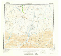 1956 Chandler Lake1959 Print · USGSNorthern Alaska's interior rivers and peaks appear here in the mid-fifties, before the era of widespread development. Researchers can trace a long TRACTOR TRAIL or locate remote Cabin sites and a Cem near the Anaktuvuk River.8 unique versions available
 - 1964 Map of Chandler Lake
 1964 Chandler Lake1964 Print · USGSThe North Slope wilderness of the early sixties is centered here at Anaktuvuk Pass, where mountain passes meet the Arctic drainage. Researchers can trace the remote Tractor Trail or locate the Cabin Grandstand Test Well and Gunsight Mtn.
 - 1971 Map of Chandler Lake A-3, 1973 Print
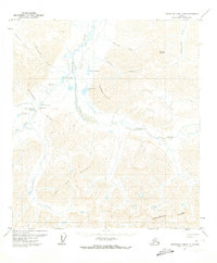 1971 Chandler Lake A-31973 Print · USGSThe Brooks Range high country comes into focus in the early 1970s, centered on the critical mountain corridor at Anaktuvuk Pass. Local historians and researchers can trace the seasonal Winter Road and locate the village Cem near the Landing Strip.3 unique versions available
End of results
Showing maps 1-4 of 4
Frequently asked questions
- What are the different types of historical maps available for Anaktuvuk Pass?
- What is the oldest map of Anaktuvuk Pass?
- Where can I purchase historical maps of Anaktuvuk Pass for my home or office?
- Where can I download high-res historical maps of Anaktuvuk Pass?
- Are there historical topographic maps available for Anaktuvuk Pass?
- Is there historical aerial imagery available for Anaktuvuk Pass?
- Where are historical maps of Anaktuvuk Pass sourced from?