Old Maps of Gordon, Alaska
Explore 6 old maps of Gordon, spanning from 1951 to today. These high-resolution historic maps reveal how streets, neighborhoods, landmarks, and natural features evolved over time — perfect for genealogy, metal detecting, research, and local history exploration.
What you can do with these maps:
- See how Gordon changed over time: Compare historical maps to modern-day views to trace roads, homesites, rail lines & more.
- View detailed metadata: Each map includes creators, publishers, year, scale, and archive source.
- Overlay maps with satellite & LiDAR: Visualize the past alongside modern tools to explore terrain & human change.
- Trusted historical sources: Maps sourced from the USGS, Library of Congress, and other archives.
- Access maps your way: View online, download high-res files, or order prints for personal or research use.
Start exploring old maps of Gordon to uncover forgotten places, hidden landmarks, and the deep history beneath your feet.
Gordon, AK maps
(6)- 1951 Map of Demarcation Point
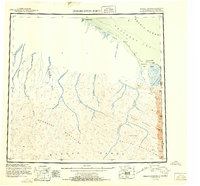 1951 Demarcation Point1951 Print · USGSThe northernmost edge of the Alaskan frontier meets the Canadian border in the early 1950s, showing a land defined by massive coastal lagoons and high mountain passes. Researchers can trace the remote settlement of Gordon or follow the paths of the Kongakut River and Jago River into the Brooks Range.4 unique versions available
 - 1955 Map of Demarcation Point
 1955 Demarcation Point1955 Print · USGSThe Arctic coastline and high peaks of the Brooks Range are captured here during the mid-fifties, showing the remote corner where Alaska meets the Yukon. Researchers can trace the Tractor Trail near the coast and locate historic sites like Gordon and the Kuluruak (Site) on Demarcation Bay.8 unique versions available
 - 1955 Map of Demarcation Point C-1, 1969 Print
 1955 Demarcation Point C-11969 Print · USGSThe northern edge of the Alaskan Arctic meets the Beaufort Sea in the mid-1950s, highlighting the remote border with the Yukon. Researchers can trace the coastal geography near Demarcation Bay, locate the settlement at Gordon (Aban'd), and follow the path of the Clarence River.2 unique versions available
 - 1964 Map of Demarcation Point
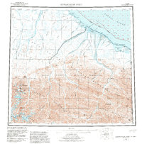
 1964 Demarcation Point1964 Print · USGSThe Arctic coast meets the Yukon border in the mid-1960s, showing a landscape of glacial peaks and coastal lagoons. Researchers can locate the settlement at Gordon and trace the paths of the Kongakut River and McCall Glacier.
 - 2018 Map of Demarcation Point C-1 NE, 2018 Print
 2018 Demarcation Point C-1 NE2018 Print · USGSCovers Gordon, including North Slope, Inuvialuit Settlement Region, and other nearby areas
 - 2024 Map of Demarcation Point C-1 NE, 2024 Print
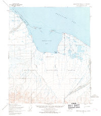
 2024 Demarcation Point C-1 NE2024 Print · USGSThe Arctic coastline at the international boundary remains a place of vast preservation and seasonal settlement in this recent survey. Researchers can locate the historic outpost of Gordon and the prominent Demarcation Point along the shores of the Beaufort Sea.
End of results
Showing maps 1-6 of 6
Frequently asked questions
- What are the different types of historical maps available for Gordon?
- What is the oldest map of Gordon?
- Where can I purchase historical maps of Gordon for my home or office?
- Where can I download high-res historical maps of Gordon?
- Are there historical topographic maps available for Gordon?
- Is there historical aerial imagery available for Gordon?
- Where are historical maps of Gordon sourced from?