1950s Maps of Gordon, Alaska
Explore 3 historic maps of Gordon from the 1950s. These maps offer a rare glimpse into what life looked like during the 1950s — showing old roads, neighborhoods, homes, and landmarks that have changed or disappeared over time.
Whether you're researching your family's past, planning a metal detecting trip, or studying how Gordon's landscape evolved across the 1950s, these high-resolution maps are a powerful tool for exploring the history of this region.
- Focus on a specific era: All maps on this page are from the 1950s, giving you a focused view of this time period.
- See what’s changed: Compare century-old streets, trails, and buildings to today's modern landscape using overlays and satellite layers.
- Research with precision: Use these maps for genealogy, historical research, land use analysis, or educational projects.
- View, download, or print: Maps are fully viewable online in high resolution, and can be downloaded or printed for your own records.
Start exploring Gordon's history through authentic maps from the 1950s. This is your window into the past.
Gordon, AK maps
(3)- 1951 Map of Demarcation Point
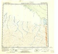 1951 Demarcation Point1951 Print · USGSThe northernmost edge of the Alaskan frontier meets the Canadian border in the early 1950s, showing a land defined by massive coastal lagoons and high mountain passes. Researchers can trace the remote settlement of Gordon or follow the paths of the Kongakut River and Jago River into the Brooks Range.4 unique versions available
 - 1955 Map of Demarcation Point
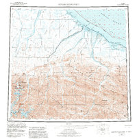 1955 Demarcation Point1955 Print · USGSThe Arctic coastline and high peaks of the Brooks Range are captured here during the mid-fifties, showing the remote corner where Alaska meets the Yukon. Researchers can trace the Tractor Trail near the coast and locate historic sites like Gordon and the Kuluruak (Site) on Demarcation Bay.8 unique versions available
 - 1955 Map of Demarcation Point C-1, 1969 Print
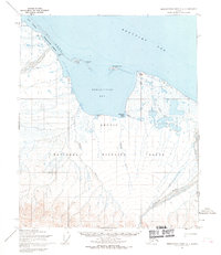 1955 Demarcation Point C-11969 Print · USGSThe northern edge of the Alaskan Arctic meets the Beaufort Sea in the mid-1950s, highlighting the remote border with the Yukon. Researchers can trace the coastal geography near Demarcation Bay, locate the settlement at Gordon (Aban'd), and follow the path of the Clarence River.2 unique versions available
End of results
Showing maps 1-3 of 3
Frequently asked questions
- What are the different types of historical maps available for Gordon?
- What is the oldest map of Gordon?
- Where can I purchase historical maps of Gordon for my home or office?
- Where can I download high-res historical maps of Gordon?
- Are there historical topographic maps available for Gordon?
- Is there historical aerial imagery available for Gordon?
- Where are historical maps of Gordon sourced from?