1900s (20th Century) Maps of Point Lay, Alaska
Explore 4 historic maps of Point Lay from the 1900s (20th Century). These maps offer a rare glimpse into what life looked like during the 1900s — showing old roads, neighborhoods, homes, and landmarks that have changed or disappeared over time.
Whether you're researching your family's past, planning a metal detecting trip, or studying how Point Lay's landscape evolved across the 1900s, these high-resolution maps are a powerful tool for exploring the history of this region.
- Focus on a specific era: All maps on this page are from the 1900s, giving you a focused view of this time period.
- See what’s changed: Compare century-old streets, trails, and buildings to today's modern landscape using overlays and satellite layers.
- Research with precision: Use these maps for genealogy, historical research, land use analysis, or educational projects.
- View, download, or print: Maps are fully viewable online in high resolution, and can be downloaded or printed for your own records.
Start exploring Point Lay's history through authentic maps from the 1900s. This is your window into the past.
Point Lay, AK maps
(4)- 1951 Map of Point Lay
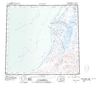 1951 Point Lay1951 Print · USGSThe Arctic coast near Point Lay in the early fifties was a landscape of barrier islands and massive lagoons. Researchers can trace seasonal routes like the Winter Trail and locate remote outposts such as Naokok and the Point Lay settlement.2 unique versions available
 - 1955 Map of Point Lay, 1964 Print
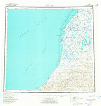 1955 Point Lay1964 Print · USGSThe Arctic coastline of Northwest Alaska is documented here during the mid-fifties, centered on the vital lagoon systems of the North Slope. Researchers can trace remote coastal routes and waterways including Kasegaluk Lagoon, the Kokolik River, and the Point Lay settlement.3 unique versions available
 - 1955 Map of Point Lay C-2, 1971 Print
 1955 Point Lay C-21971 Print · USGSThe Arctic coast of the North Slope appears in the mid-1950s as a frontier of isolated river outposts and coastal lagoons. Trace the early infrastructure of Elmer, Brant, and Garner or locate the remote Quonset Hut and Cem along the Kukpowruk River.
 - 1965 Map of Point Lay
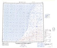 1965 Point Lay1965 Print · USGSThe North Slope coast near Point Lay is captured here in the mid-1960s, showing a landscape of barrier islands and vast tundra waterways. Researchers can locate remote sites like Omalik, trace the Kukpowruk River, and find local landmarks such as a Cem or Cabin.
End of results
Showing maps 1-4 of 4
Frequently asked questions
- What are the different types of historical maps available for Point Lay?
- What is the oldest map of Point Lay?
- Where can I purchase historical maps of Point Lay for my home or office?
- Where can I download high-res historical maps of Point Lay?
- Are there historical topographic maps available for Point Lay?
- Is there historical aerial imagery available for Point Lay?
- Where are historical maps of Point Lay sourced from?