Old Maps of Point Lay, Alaska for Academic Research
Study the evolution of Point Lay with 5 high-resolution historic maps. Whether you're teaching, researching, or modeling changes in land use, these maps provide essential visual documentation of urban, environmental, and geographic change.
- Analyze long-term change: Track patterns in development, transportation, and natural features.
- Ideal for environmental or urban studies: Support academic projects with primary historical map data.
- Use in the classroom or lab: Educators and researchers rely on these maps to bring historical context to life.
These maps are a powerful tool for teaching, research, and visualizing how Point Lay has changed over the decades.
Point Lay, AK maps
(5)- 1951 Map of Point Lay
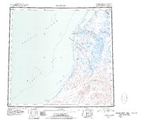 1951 Point Lay1951 Print · USGSThe Arctic coast near Point Lay in the early fifties was a landscape of barrier islands and massive lagoons. Researchers can trace seasonal routes like the Winter Trail and locate remote outposts such as Naokok and the Point Lay settlement.2 unique versions available
 - 1955 Map of Point Lay, 1964 Print
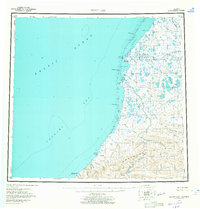 1955 Point Lay1964 Print · USGSThe Arctic coastline of Northwest Alaska is documented here during the mid-fifties, centered on the vital lagoon systems of the North Slope. Researchers can trace remote coastal routes and waterways including Kasegaluk Lagoon, the Kokolik River, and the Point Lay settlement.3 unique versions available
 - 1955 Map of Point Lay C-2, 1971 Print
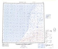
 1955 Point Lay C-21971 Print · USGSThe Arctic coast of the North Slope appears in the mid-1950s as a frontier of isolated river outposts and coastal lagoons. Trace the early infrastructure of Elmer, Brant, and Garner or locate the remote Quonset Hut and Cem along the Kukpowruk River.
 - 1965 Map of Point Lay
 1965 Point Lay1965 Print · USGSThe North Slope coast near Point Lay is captured here in the mid-1960s, showing a landscape of barrier islands and vast tundra waterways. Researchers can locate remote sites like Omalik, trace the Kukpowruk River, and find local landmarks such as a Cem or Cabin.
 - 2014 Map of Point Lay C-2 NW, 2014 Print
 2014 Point Lay C-2 NW2014 Print · USGSThe remote village of Point Lay and its Arctic coastal surroundings are documented in this 2014 survey. Genealogists and researchers can trace the local street grid and the vital Point Lay LRRS Airport near the waters of Kasegaluk Lagoon.
End of results
Showing maps 1-5 of 5
Frequently asked questions
- What are the different types of historical maps available for Point Lay?
- What is the oldest map of Point Lay?
- Where can I purchase historical maps of Point Lay for my home or office?
- Where can I download high-res historical maps of Point Lay?
- Are there historical topographic maps available for Point Lay?
- Is there historical aerial imagery available for Point Lay?
- Where are historical maps of Point Lay sourced from?