Old Maps of Sagwon, Alaska for Metal Detecting
Plan your next treasure hunt with 6 historic maps of Sagwon. Find old homesites, ghost towns, trails, and gathering spots that may be lost to time — perfect for identifying promising metal detecting locations.
- Locate forgotten sites: Uncover places like long-lost settlements, abandoned rail lines, or gathering spots.
- Plan better hunts: Use map overlays combined with LiDAR or satellite views to narrow in on historically rich areas.
- Made for detectorists: Thousands of hobbyists use these maps to discover relics, coins, and hidden history.
Use these historic maps to boost your research and find new opportunities beneath the surface of Sagwon.
Sagwon, AK maps
(6)- 1951 Map of Sagavanirktok D-5
 1951 Sagavanirktok D-51951 Print · USGSAlaska's North Slope in the early fifties remains a wilderness of braided rivers and unmapped peaks during this naval petroleum survey. Researchers can trace the complex courses of the Sagavanirktok River and Ivishak River as they flow out of the Franklin Mountains.
 - 1956 Map of Sagavanirktok, 1961 Print
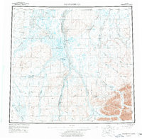
 1956 Sagavanirktok1961 Print · USGSThe North Slope of Alaska appears in the mid-fifties as a wild expanse of braided rivers and tundra before the oil era. Trace the path of the Tractor Trail past Franklin Bluffs and the remote Cache One Lake.5 unique versions available
 - 1958 Map of Sagavanirktok, 1977 Print
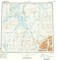
 1958 Sagavanirktok1977 Print · USGSThe North Slope during the late fifties and mid-seventies reveals the early infrastructure of the Arctic energy corridor. Researchers can trace the Pipeline (Under Construction) past remote sites like Franklin Bluffs and Sagwon.4 unique versions available
 - 1964 Map of Sagavanirktok
 1964 Sagavanirktok1964 Print · USGSThe Alaska North Slope appears here in the mid-twentieth century, before the era of major industrial oil development. You can trace the massive braided channels of the Sagavanirktok River past Franklin Bluffs and locate remote survey markers like VABM 1352 Otik.
 - 1971 Map of Sagavanirktok B-3, 1973 Print
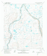 1971 Sagavanirktok B-31973 Print · USGSNorth Slope transportation and river systems are captured here in the early seventies during a period of Arctic exploration. Researchers can trace seasonal routes like the Winter Road and Winter Trail near Sagwon and the Ivishak River.2 unique versions available
 - 2017 Map of Sagavanirktok B-3 SW, 2017 Print
 2017 Sagavanirktok B-3 SW2017 Print · USGSThe North Slope landscape is captured here in the early twenty-first century, showing the critical junction where energy industry meets the arctic wilderness. Researchers can trace the path of the Alaska Pipeline as it mirrors the Sagavanirktok River near Sagwon.
End of results
Showing maps 1-6 of 6
Frequently asked questions
- What are the different types of historical maps available for Sagwon?
- What is the oldest map of Sagwon?
- Where can I purchase historical maps of Sagwon for my home or office?
- Where can I download high-res historical maps of Sagwon?
- Are there historical topographic maps available for Sagwon?
- Is there historical aerial imagery available for Sagwon?
- Where are historical maps of Sagwon sourced from?