Old Maps of Deering, Alaska for Academic Research
Study the evolution of Deering with 6 high-resolution historic maps. Whether you're teaching, researching, or modeling changes in land use, these maps provide essential visual documentation of urban, environmental, and geographic change.
- Analyze long-term change: Track patterns in development, transportation, and natural features.
- Ideal for environmental or urban studies: Support academic projects with primary historical map data.
- Use in the classroom or lab: Educators and researchers rely on these maps to bring historical context to life.
These maps are a powerful tool for teaching, research, and visualizing how Deering has changed over the decades.
Deering, AK maps
(6)- 1950 Map of Kotzebue A-2, 1957 Print
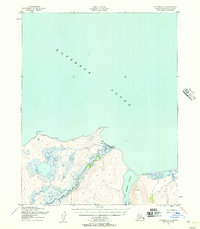 1950 Kotzebue A-21957 Print · USGSThe northern coast of the Seward Peninsula is documented here during the early fifties, centering on the remote village of Deering. Researchers can trace the coastal landscape around Cape Deceit and the original Landing Strip near the mouth of the Inmachuk River.3 unique versions available
 - 1951 Map of Kotzebue
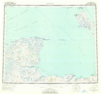 1951 Kotzebue1951 Print · USGSNorthwestern Alaska at the start of the 1950s reveals a landscape defined by the Baldwin Peninsula and coastal outposts. Researchers can trace the Winter Trail and locate sites like Deering, Espenberg, and the Landplane Airport.5 unique versions available
 - 1958 Map of Kotzebue
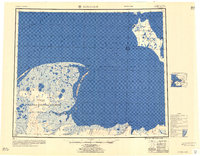 1958 Kotzebue1958 Print · USGSThe Arctic coastline and the northern edge of the Seward Peninsula are captured here during the late fifties. Researchers can trace early aviation and maritime sites, from the Commercial Airport at Kotzebue to the remote cabins along the Serpentine River.
 - 1964 Map of Kotzebue
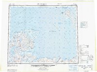 1964 Kotzebue1964 Print · USGSThe Northwest Arctic coast during the mid-sixties reveals a landscape of isolated seasonal trails and maritime outposts. Researchers can trace the Winter Trail across the tundra to settlements like Deering, Kotzebue, and Singreak.
 - 2018 Map of Kotzebue A-2 SE, 2018 Print
 2018 Kotzebue A-2 SE2018 Print · USGSThe coastal village of Deering is documented here as it appeared in the late twenty-teens. Researchers can trace the local street grid near Cape Deceit and the mouth of the Inmachuk River.
 - 2018 Map of Kotzebue A-2 SW, 2018 Print
 2018 Kotzebue A-2 SW2018 Print · USGSThe coastal tundra of the Seward Peninsula is captured here in the late 2010s, showing the intersection of the Kotzebue Sound and local transit routes. Researchers can trace the path of Deering Road as it nears the Deering Airport and the waters of Toawlevic Point.
End of results
Showing maps 1-6 of 6
Frequently asked questions
- What are the different types of historical maps available for Deering?
- What is the oldest map of Deering?
- Where can I purchase historical maps of Deering for my home or office?
- Where can I download high-res historical maps of Deering?
- Are there historical topographic maps available for Deering?
- Is there historical aerial imagery available for Deering?
- Where are historical maps of Deering sourced from?