1900s (20th Century) Maps of Klery Creek, Alaska
Explore 4 historic maps of Klery Creek from the 1900s (20th Century). These maps offer a rare glimpse into what life looked like during the 1900s — showing old roads, neighborhoods, homes, and landmarks that have changed or disappeared over time.
Whether you're researching your family's past, planning a metal detecting trip, or studying how Klery Creek's landscape evolved across the 1900s, these high-resolution maps are a powerful tool for exploring the history of this region.
- Focus on a specific era: All maps on this page are from the 1900s, giving you a focused view of this time period.
- See what’s changed: Compare century-old streets, trails, and buildings to today's modern landscape using overlays and satellite layers.
- Research with precision: Use these maps for genealogy, historical research, land use analysis, or educational projects.
- View, download, or print: Maps are fully viewable online in high resolution, and can be downloaded or printed for your own records.
Start exploring Klery Creek's history through authentic maps from the 1900s. This is your window into the past.
Klery Creek, AK maps
(4)- 1951 Map of Baird Mountains
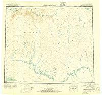 1951 Baird Mountains1951 Print · USGSThe northern Alaskan interior at the start of the 1950s reveals a vast river-and-mountain landscape shaped by the Brooks Range. Researchers can trace early mining sites like Klery Creek, the Winter Trail, and the remote Central settlement.3 unique versions available
 - 1955 Map of Baird Mountains A-3, 1970 Print
 1955 Baird Mountains A-31970 Print · USGSThe Northwest Arctic interior in the mid-fifties was a landscape of remote mountain ranges and vital waterways. Researchers can locate isolated Cabins along Klery Creek and trace the original path of the Winter Trail.
 - 1956 Map of Baird Mountains, 1965 Print
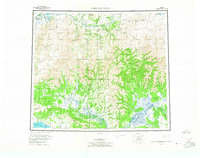 1956 Baird Mountains1965 Print · USGSThe Northwest Arctic interior is captured here in the mid-1950s, centered on the drainage of the Noatak River as it cuts through the Baird Mountains. Researchers can trace the winding paths of the Squirrel River and locate remote landmarks like Deviation Peak and the Grand Canyon.7 unique versions available
 - 1965 Map of Baird Mountains
 1965 Baird Mountains1965 Print · USGSThe Northwest Arctic wilderness is captured here in the mid-fifties, showing the vast drainages of the Noatak and Kobuk rivers. Researchers can trace remote landmarks like the Klery Creek Landing Strip, the Grand Canyon, and Sekuak Bluff.
End of results
Showing maps 1-4 of 4
Top cities near Klery Creek
Frequently asked questions
- What are the different types of historical maps available for Klery Creek?
- What is the oldest map of Klery Creek?
- Where can I purchase historical maps of Klery Creek for my home or office?
- Where can I download high-res historical maps of Klery Creek?
- Are there historical topographic maps available for Klery Creek?
- Is there historical aerial imagery available for Klery Creek?
- Where are historical maps of Klery Creek sourced from?