Old Maps of Rowan Bay, Alaska for Academic Research
Study the evolution of Rowan Bay with 8 high-resolution historic maps. Whether you're teaching, researching, or modeling changes in land use, these maps provide essential visual documentation of urban, environmental, and geographic change.
- Analyze long-term change: Track patterns in development, transportation, and natural features.
- Ideal for environmental or urban studies: Support academic projects with primary historical map data.
- Use in the classroom or lab: Educators and researchers rely on these maps to bring historical context to life.
These maps are a powerful tool for teaching, research, and visualizing how Rowan Bay has changed over the decades.
Rowan Bay, AK maps
(8)- 1948 Map of Port Alexander C-1, 1957 Print
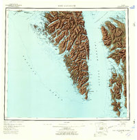
 1948 Port Alexander C-11957 Print · USGSKuiu Island in the years following World War II reveals a landscape of isolated coastal industry and deep wilderness. Researchers can trace the maritime footprint of the Pillar Bay Cannery and locate remote outposts like Beck and Ben.
 - 1951 Map of Port Alexander, 1959 Print
 1951 Port Alexander1959 Print · USGSSoutheast Alaska in the early fifties shows a rugged maritime landscape defined by isolated fishing outposts and steep coastal mountains. Trace the locations of historic settlements like Port Alexander, the Lodge at Crawfish Inlet, and the post office at Goddard (Hot Springs P O).5 unique versions available
 - 1951 Map of Port Alexander C-1, 1967 Print
 1951 Port Alexander C-11967 Print · USGSKuiu Island in the early fifties was a hub for the Southeast Alaska fishing industry centered on the Bay of Pillars. Researchers can trace the layout of the Pillar Bay Cannery, the Seaplane Base, and remote sites like Piledriver Cove.3 unique versions available
 - 1952 Map of Port Alexander, 1953 Print
 1952 Port Alexander1953 Print · USGSThe remote coastline of the First Judicial Division is documented here in the early fifties, featuring the isolated outpost of Port Alexander. Researchers can trace the maritime footprint of the era through scattered cabins, the Saginaw Bay Cannery, and the Lighthouse at Cape Decision.4 unique versions available
 - 1964 Map of Port Alexander
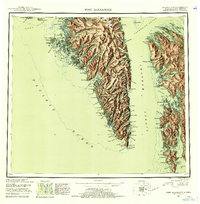
 1964 Port Alexander1964 Print · USGSSoutheast Alaska in the mid-1960s was a landscape of remote coastal outposts and cannery towns connected by the sea. Trace the maritime history of the Alexander Archipelago through sites like Goddard, the Pillar Bay Cannery, and the isolated Lighthouse at Cape Decision.
 - 1997 Map of Port Alexander C-1, 2000 Print
 1997 Port Alexander C-12000 Print · USGSKuiu Island in the late nineties shows a landscape where industrial history meets wilderness preservation. Researchers can trace the remnants of coastal commerce at Pillar Bay Cannery (Abandoned) and find remote outposts like Logging Camp or Monark.
 - 2017 Map of Port Alexander C-1 NW, 2017 Print
 2017 Port Alexander C-1 NW2017 Print · USGSCovers Rowan Bay, including Petersburg Borough, United States, and other nearby areas
 - 2021 Map of Port Alexander C-1 NW, 2021 Print
 2021 Port Alexander C-1 NW2021 Print · USGSKuiu Island's maritime landscape is captured in the early twenty-first century, showing the remote waters of the Tongass National Forest. You can trace the coastline from Rowan Bay to the uniquely named Lost Men and locate the settlement at Behind Camp.
End of results
Showing maps 1-8 of 8
Frequently asked questions
- What are the different types of historical maps available for Rowan Bay?
- What is the oldest map of Rowan Bay?
- Where can I purchase historical maps of Rowan Bay for my home or office?
- Where can I download high-res historical maps of Rowan Bay?
- Are there historical topographic maps available for Rowan Bay?
- Is there historical aerial imagery available for Rowan Bay?
- Where are historical maps of Rowan Bay sourced from?