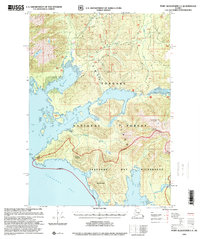
1997 Map of Port Alexander C-1
USGS Topo · Published 2000About this map
Kuiu Island provides a detailed look at the maritime and industrial footprint within the Tongass National Forest during the late 20th century. The intricate shoreline is defined by the Bay of Pillars, Tebenkof Bay, and Elena Bay, where the landscape transitions from sea-level coves to peaks like Piledriver Mountain and Ellis Mountain. A significant historical detail is the presence of the Pillar Bay Cannery (Abandoned) and nearby ruins, indicating the area's legacy in the Alaskan fishing industry.
Find a feature on this map
42 named features on this map. Tap any name to fly to it.
Don’t see what you’re looking for? This feature index may not catch every label — zoom into the map to look around manually.
Map Details
Editions of this 1997 Port Alexander C-1 Map
This is the sole edition of this map. No revisions or reprints were ever made.
Other maps of this area

1948 · Port Alexander C-1
USGS Topo · 1:63,360

1948 · Petersburg B-6
USGS Topo · 1:63,360

1948 · Port Alexander B-1
USGS Topo · 1:63,360

1948 · Petersburg D-6
USGS Topo · 1:63,360

1948 · Port Alexander D-1
USGS Topo · 1:63,360

1948 · Petersburg C-6
USGS Topo · 1:63,360

1948 · Port Alexander B-2
USGS Topo · 1:63,360

1951 · Port Alexander C-2
USGS Topo · 1:63,360

1951 · Port Alexander
USGS Topo · 1:250,000

1951 · Port Alexander D-2
USGS Topo · 1:63,360