Old Maps of Hollis, Alaska for Hiking & Exploration
Hike through history with 6 historic maps of Hollis. Explore old trails, ghost towns, and forgotten backroads — perfect for outdoor adventurers and local explorers.
- Rediscover forgotten places: Map out old mining camps, roads, and footpaths that no longer exist on modern maps.
- Layer with modern tools: Combine with LiDAR or satellite views to plan hikes through historical terrain.
- Made for exploration: Popular among hikers, overlanders, and local history lovers.
Use these maps to find adventure and explore the hidden past of Hollis.
Hollis, AK maps
(6)- 1949 Map of Craig B-2, 1964 Print
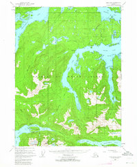 1949 Craig B-21964 Print · USGSThe intricate fjords of Prince of Wales Island are shown here just as post-war aviation and maritime traffic began to transform the archipelago. Researchers can trace the early industrial footprint of the Khayyam Mine and the historic Sulzer Portage near the settlement of Hollis.3 unique versions available
 - 1951 Map of Craig B-2, 1952 Print
 1951 Craig B-21952 Print · USGSSoutheast Alaska in the early fifties was a landscape of maritime industry and wilderness. Trace the remnants of coastal mining and heritage at Old Kasaan Nat Mon, the Khayam Mine (Inactive), and the site of Sulzer (Aban'd).2 unique versions available
 - 1957 Map of Craig, 1959 Print
 1957 Craig1959 Print · USGSSoutheast Alaska’s intricate archipelago is revealed in the mid-1950s, detailing a coastal economy driven by remote mines and fishing outposts. Genealogists and historians can trace family roots in Craig, Hydaburg, and Klawak, or locate former sites like Tuxekan and the Salt Chuck Mine.3 unique versions available
 - 1997 Map of Craig B-2, 2000 Print
 1997 Craig B-22000 Print · USGSPrince of Wales Island in the late nineties shows a landscape of deep fjords and industrial timber operations within the Tongass National Forest. Trace historical resource sites like the Khayyam Mine or the remote Logging Camp and Hollis settlements.
 - 2017 Map of Craig B-2 NW, 2017 Print
 2017 Craig B-2 NW2017 Print · USGSCovers Hollis, including Unorganized Borough, Prince of Wales-Hyder, and other nearby areas
 - 2021 Map of Craig B-2 NW, 2021 Print
 2021 Craig B-2 NW2021 Print · USGSPrince of Wales Island's coastal timberlands and complex waterways are documented here in the modern era. Trace the island's geography from maritime points like Kajusgidas Point to inland features such as Old Franks Lake and Kina Lake.
End of results
Showing maps 1-6 of 6
Top cities near Hollis
Frequently asked questions
- What are the different types of historical maps available for Hollis?
- What is the oldest map of Hollis?
- Where can I purchase historical maps of Hollis for my home or office?
- Where can I download high-res historical maps of Hollis?
- Are there historical topographic maps available for Hollis?
- Is there historical aerial imagery available for Hollis?
- Where are historical maps of Hollis sourced from?