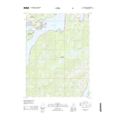
2017 Map of Craig B-2 NW
USGS Topo · Published 2017About this map
Hollis sits at the northern edge of this coastal landscape, situated where Twelvemile Arm meets the inlet of Hollis Anchorage. This territory within the Tongass National Forest is defined by a dense network of timbered ridges and waterways, including the prominent W Ridge in the southeast. Moving inland from the Pacific Ocean, the terrain reveals a series of freshwater bodies like Kina Lake, Old Franks Lake, and the smaller Lake Mary. The coastline is jagged with features such as Althouse Point and Clark Bay, while small landmasses like Cat Island and Loy Island guard the harbor. Infrastructure is sparse, primarily consisting of the Maybeso Road near the settlement and forest service routes like 2135500 Rd that navigate the drainages of Cabin Creek and Kina Cr.
Find a feature on this map
27 named features on this map. Tap any name to fly to it.
Don’t see what you’re looking for? This feature index may not catch every label — zoom into the map to look around manually.
Map Details
Editions of this 2017 Craig B-2 NW Map
This is the sole edition of this map. No revisions or reprints were ever made.
Other maps of this area

1949 · Craig C-2
USGS Topo · 1:63,360

1949 · Craig B-2
USGS Topo · 1:63,360

1949 · Craig B-3
USGS Topo · 1:63,360

1949 · Craig C-3
USGS Topo · 1:63,360

1951 · Craig C-3
USGS Topo · 1:63,360

1951 · Craig B-2
USGS Topo · 1:63,360

1951 · Craig C-2
USGS Topo · 1:63,360

1951 · Craig B-3
USGS Topo · 1:63,360

1957 · Craig
USGS Topo · 1:250,000
1994 · Craig C-2
USGS Topo · 1:63,360