
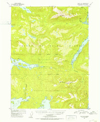
1951 Map of Craig B-3
USGS Topo · Published 1953About this map
Prince of Wales Island is documented here during the early 1950s, revealing an industrial landscape defined by mining activity and maritime infrastructure. The settlement of Hollis serves as a focal point near Hollis Anchorage, while further inland, the Dawson Mine and the Puyallup Mine (Aband) illustrate the shifting fortunes of mineral extraction. An Aerial Tramway and a Gaging Station near the Harris River show the mechanical systems used to navigate and monitor this coastal environment. Extensive boundaries for the Hydaburg Indian Reservation and a Military Reservation Boundary overlay the terrain, intersecting at a central Cable House near Twelvemile Arm. This survey reflects a post-war era of federal administration and resource management within the Tongass National Forest, where coastal inlets like Soda Bay and Trocadero Bay provided critical access to the interior.
Find a feature on this map
32 named features on this map. Tap any name to fly to it.
Don’t see what you’re looking for? This feature index may not catch every label — zoom into the map to look around manually.
Map Details
Editions of this 1951 Craig B-3 Map
2 editions found
Other maps of this area

1948 · Craig A-4
USGS Topo · 1:63,360

1948 · Craig A-3
USGS Topo · 1:63,360

1948 · Craig A-2
USGS Topo · 1:63,360

1949 · Craig C-2
USGS Topo · 1:63,360

1949 · Craig B-2
USGS Topo · 1:63,360

1949 · Craig B-3
USGS Topo · 1:63,360

1949 · Craig C-3
USGS Topo · 1:63,360

1949 · Craig C-4
USGS Topo · 1:63,360

1949 · Craig B-4
USGS Topo · 1:63,360

1951 · Craig C-3
USGS Topo · 1:63,360