Old Maps of Metlakatla, Alaska for Metal Detecting
Plan your next treasure hunt with 5 historic maps of Metlakatla. Find old homesites, ghost towns, trails, and gathering spots that may be lost to time — perfect for identifying promising metal detecting locations.
- Locate forgotten sites: Uncover places like long-lost settlements, abandoned rail lines, or gathering spots.
- Plan better hunts: Use map overlays combined with LiDAR or satellite views to narrow in on historically rich areas.
- Made for detectorists: Thousands of hobbyists use these maps to discover relics, coins, and hidden history.
Use these historic maps to boost your research and find new opportunities beneath the surface of Metlakatla.
Metlakatla, AK maps
(5)- 1952 Map of Ketchikan, 1953 Print
 1952 Ketchikan1953 Print · USGSThe Ketchikan region of Southeast Alaska is mapped here in the early fifties, documenting the remote settlements and deep-water inlets of the southern panhandle. Genealogists and historians can trace the foundations of Ketchikan, Metlakatla, and Saxman alongside lonely backcountry cabins.4 unique versions available
 - 1955 Map of Ketchikan A-5, 1959 Print
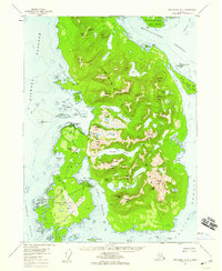 1955 Ketchikan A-51959 Print · USGSAnnette Island in the mid-fifties was a vital hub for both the local fishing industry and regional aviation. You can trace the infrastructure of Metlakatla, from the Metlakatla Cannery to the runways and Pass Terminal of the Annette Island Airport.3 unique versions available
 - 1955 Map of Ketchikan, 1966 Print
 1955 Ketchikan1966 Print · USGSSoutheast Alaska’s maritime character is captured in the mid-fifties, showing the vital waterways and remote outposts of the Alexander Archipelago. Researchers can trace the waterfronts of Ketchikan and Metlakatla or locate isolated spots like Hyder and Loring.3 unique versions available
 - 2017 Map of Ketchikan A-5 NW, 2017 Print
 2017 Ketchikan A-5 NW2017 Print · USGSCovers Metlakatla, including Unorganized Borough, Prince of Wales-Hyder, and other nearby areas
 - 2021 Map of Ketchikan A-5 NW, 2021 Print
 2021 Ketchikan A-5 NW2021 Print · USGSAnnette Island in the early 2020s shows a landscape where high peaks meet the waters of Nichols Passage. Researchers can trace the local street network near Village Point or locate landmarks like Leadville Mtn and Helen Todd Lake within the reserve.
End of results
Showing maps 1-5 of 5
Top cities near Metlakatla
Frequently asked questions
- What are the different types of historical maps available for Metlakatla?
- What is the oldest map of Metlakatla?
- Where can I purchase historical maps of Metlakatla for my home or office?
- Where can I download high-res historical maps of Metlakatla?
- Are there historical topographic maps available for Metlakatla?
- Is there historical aerial imagery available for Metlakatla?
- Where are historical maps of Metlakatla sourced from?