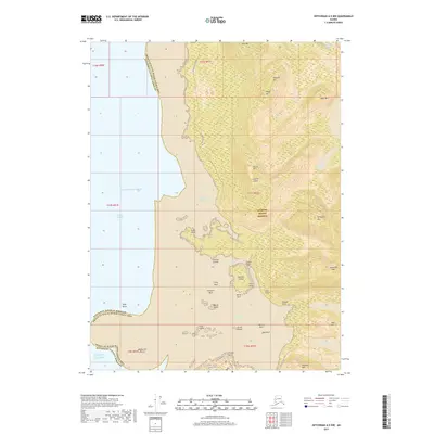
2017 Map of Ketchikan A-5 NW
USGS Topo · Published 2017About this map
The Annette Island Reserve dominates this coastal landscape, where the rugged topography of the Alexander Archipelago meets the Gulf of Alaska. Near the southern portion of the map, a small street grid including Hillcrest Avenue and Tafts Street serves the community near Village Point. This area reveals the maritime-focused settlement patterns of the region, with names like Port Chester and Sylburn Harbor indicating protected waters essential for coastal travel. High peaks such as Chenango Mtn and Janesville Mtn rise sharply from the shoreline, while inland freshwater bodies like Helen Todd Lake and Melanson Lake are tucked into the high elevations. The intricate coastline is dotted with numerous hazards and landmarks, from the Kelp Rocks to Lively Rock, reflecting the navigational complexity of Nichols Passage.
Find a feature on this map
51 named features on this map. Tap any name to fly to it.
Don’t see what you’re looking for? This feature index may not catch every label — zoom into the map to look around manually.
Map Details
Editions of this 2017 Ketchikan A-5 NW Map
This is the sole edition of this map. No revisions or reprints were ever made.
Other maps of this area

1948 · Ketchikan A-6
USGS Topo · 1:63,360

1952 · Ketchikan
USGS Topo · 1:250,000

1953 · Ketchikan B-6
USGS Topo · 1:63,360

1954 · Ketchikan B-5
USGS Topo · 1:63,360

1954 · Ketchikan B-6
USGS Topo · 1:63,360

1955 · Ketchikan A-5
USGS Topo · 1:63,360

1955 · Ketchikan
USGS Topo · 1:250,000

1955 · Ketchikan B-5
USGS Topo · 1:63,360
1991 · Ketchikan B-5 SW
USGS Topo · 1:25,000
1991 · Ketchikan B-6 SE
USGS Topo · 1:25,000