
Loading...
Loading map...1955 Map of Ketchikan
USGS Topo · Published 1966About this map
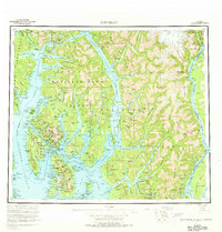
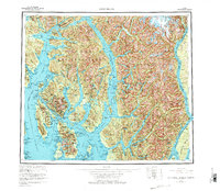
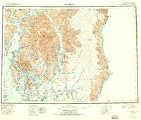
The complex coastal geography of the Alexander Archipelago is charted in this mid-century survey, centered on the hub of Ketchikan. The map documents the intricate waterway system defining the region, where the Tongass Narrows separates the mainland and Revillagigedo Island from Gravina Island. To the south, Annette Island serves as a significant landmark, featuring the Annette Island Airport and the community of Metlakatla.
Find a feature on this map
81 named features on this map. Tap any name to fly to it.
Don’t see what you’re looking for? This feature index may not catch every label — zoom into the map to look around manually.
Map Details
Date Portrayed1955
Date Published1966
PublisherU.S. Geological Survey
Map TypeTopographic
Scale1:250,000
Physical Dimensions23 x 24.1 inches
Editions of this 1955 Ketchikan Map
3 editions found
Historical Maps of Ketchikan Through Time
Featured Locations
Source Details
SourceU.S. Geological Survey
CopyrightPublic Domain