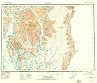
1952 Map of Ketchikan
USGS Topo · Published 1955About this map
Revillagigedo Island and the surrounding Alexander Archipelago dominate this early 1950s reconnaissance, which details the complex fjords and coastal communities of the southern panhandle. The city of Ketchikan serves as the regional hub, connected to the nearby settlement of Saxman and the Tongass Highway. To the south, the Annette Island Reserve is a prominent feature, home to Metlakatla and the Annette Island Airfield. The map traces the international boundary between the United States and Canada along the Portland Canal, where the isolated settlement of Hyder sits at the head of the waterway. Coastal navigation and resource management are evident through the placement of a U.S. Coast Guard Station and the vast extent of the Tongass National Forest. Deep inlets like Behm Canal and Boca de Quadra carve into the mainland, illustrating the region's reliance on maritime transport and fishing for connectivity between remote outposts like Loring and Cape Fox Village.
Find a feature on this map
77 named features on this map. Tap any name to fly to it.
Don’t see what you’re looking for? This feature index may not catch every label — zoom into the map to look around manually.
Map Details
Editions of this 1952 Ketchikan Map
4 editions found

Other maps of this area

1948 · Petersburg A-1
USGS Topo · 1:63,360

1948 · Prince Rupert D-6
USGS Topo · 1:63,360

1948 · Ketchikan A-6
USGS Topo · 1:63,360

1948 · Craig A-1
USGS Topo · 1:63,360

1948 · Dixon Entrance D-1
USGS Topo · 1:63,360

1948 · Ketchikan C-5
USGS Topo · 1:63,360

1949 · Ketchikan C-6
USGS Topo · 1:63,360

1949 · Ketchikan B-4
USGS Topo · 1:63,360

1949 · Craig B-1
USGS Topo · 1:63,360

1949 · Craig D-1
USGS Topo · 1:63,360