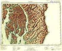
1952 Map of Ketchikan
USGS Topo · Published 1953About this map
Revillagigedo Island and the surrounding Alexander Archipelago waterways dominate this 1952 reconnaissance survey, illustrating the complex geography of Southeast Alaska before modern development. The primary settlement of Ketchikan is shown alongside smaller communities like Saxman, Metlakatla, and Loring. The map documents the region's reliance on maritime access, featuring narrow passages like Tongass Narrows and expansive inlets such as Behm Canal and Portland Canal, the latter of which defines the boundary between the United States and Canada.
Find a feature on this map
135 named features on this map. Tap any name to fly to it.
Don’t see what you’re looking for? This feature index may not catch every label — zoom into the map to look around manually.
Map Details
Editions of this 1952 Ketchikan Map
4 editions found

Other maps of this area

1948 · Petersburg A-1
USGS Topo · 1:63,360

1948 · Prince Rupert D-6
USGS Topo · 1:63,360

1948 · Ketchikan A-6
USGS Topo · 1:63,360

1948 · Craig A-1
USGS Topo · 1:63,360

1948 · Dixon Entrance D-1
USGS Topo · 1:63,360

1948 · Ketchikan C-5
USGS Topo · 1:63,360

1949 · Ketchikan C-6
USGS Topo · 1:63,360

1949 · Ketchikan B-4
USGS Topo · 1:63,360

1949 · Craig B-1
USGS Topo · 1:63,360

1949 · Craig D-1
USGS Topo · 1:63,360