
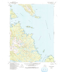
1949 Map of Craig B-1
USGS Topo · Published 1965About this map
The southeastern reaches of Prince of Wales Island are defined by an intricate network of waterways including Kasaan Bay and Cholmondeley Sound. This 1949 topographic study, situated entirely within the Tongass National Forest, documents a maritime landscape where the Kasaan Peninsula and dozens of smaller islands like Grindall Island and Patterson Island dominate the geography. The map captures the coastline before extensive modern development, showing the natural shoreline of Skowl Arm and secluded inlets such as Saltery Cove. Inland, the terrain rises sharply to distinctive peaks like Clover Mtn and Nipple Butte, with drainages like Sunny Creek feeding into the surrounding straits. The lack of roads or established trails on this sheet reflects the remote, water-dependent nature of life in the Alexander Archipelago during the mid-twentieth century.
Find a feature on this map
46 named features on this map. Tap any name to fly to it.
Don’t see what you’re looking for? This feature index may not catch every label — zoom into the map to look around manually.
Map Details
Editions of this 1949 Craig B-1 Map
2 editions found
Other maps of this area

1948 · Ketchikan A-6
USGS Topo · 1:63,360

1948 · Craig A-1
USGS Topo · 1:63,360

1948 · Craig A-2
USGS Topo · 1:63,360

1949 · Craig C-2
USGS Topo · 1:63,360

1949 · Craig B-2
USGS Topo · 1:63,360

1949 · Ketchikan C-6
USGS Topo · 1:63,360

1950 · Craig B-1
USGS Topo · 1:63,360

1950 · Craig C-1
USGS Topo · 1:63,360

1951 · Craig B-2
USGS Topo · 1:63,360

1951 · Craig C-2
USGS Topo · 1:63,360