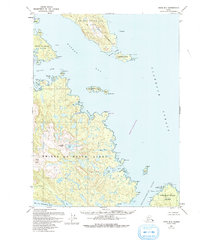
1949 Map of Craig B-1
USGS Topo · Published 1993About this map
Prince of Wales Island dominates this mid-century topographic survey, showing a landscape defined by complex maritime geography within the Tongass National Forest. The sheet captures the intricate coastline of the Kasaan Peninsula and the sheltered waters of Kasaan Bay, where landmarks like Grindall Island and Patterson Island mark the passage toward Clarence Strait. Along the southern reach, the map details the deep inlets of Cholmondeley Sound and its West Arm.
Find a feature on this map
38 named features on this map. Tap any name to fly to it.
Don’t see what you’re looking for? This feature index may not catch every label — zoom into the map to look around manually.
Map Details
Editions of this 1949 Craig B-1 Map
2 editions found
Other maps of this area

1948 · Ketchikan A-6
USGS Topo · 1:63,360

1948 · Craig A-1
USGS Topo · 1:63,360

1948 · Craig A-2
USGS Topo · 1:63,360

1949 · Craig C-2
USGS Topo · 1:63,360

1949 · Craig B-2
USGS Topo · 1:63,360

1949 · Ketchikan C-6
USGS Topo · 1:63,360

1949 · Craig B-1
USGS Topo · 1:63,360

1950 · Craig B-1
USGS Topo · 1:63,360

1950 · Craig C-1
USGS Topo · 1:63,360

1951 · Craig B-2
USGS Topo · 1:63,360