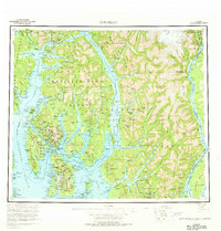
1955 Map of Ketchikan
USGS Topo · Published 1969About this map
Ketchikan serves as the focal point for this mid-century look at the maritime geography of Southeast Alaska, where the Tongass National Forest dominates the massive Revillagigedo Island. This survey captures the region during a period of steady growth for the fishing and timber industries, showing the intricate network of glacial fjords like Behm Canal and Portland Canal that define the international boundary with British Columbia. The map reveals the distinct settlement patterns of the era, from the fishing hub of Loring to the established communities of Saxman and Metlakatla on Annette Island. Beyond the coastal towns, the landscape is defined by the steep drainages of the Unuk River and Chickamin River, illustrating the reliance on water transport for connecting these remote outposts before the expansion of modern air travel.
Find a feature on this map
36 named features on this map. Tap any name to fly to it.
Don’t see what you’re looking for? This feature index may not catch every label — zoom into the map to look around manually.
Map Details
Editions of this 1955 Ketchikan Map
3 editions found

Other maps of this area

1948 · Petersburg A-1
USGS Topo · 1:63,360

1948 · Prince Rupert D-6
USGS Topo · 1:63,360

1948 · Ketchikan A-6
USGS Topo · 1:63,360

1948 · Craig A-1
USGS Topo · 1:63,360

1948 · Dixon Entrance D-1
USGS Topo · 1:63,360

1948 · Ketchikan C-5
USGS Topo · 1:63,360

1949 · Ketchikan C-6
USGS Topo · 1:63,360

1949 · Ketchikan B-4
USGS Topo · 1:63,360

1949 · Craig B-1
USGS Topo · 1:63,360

1949 · Craig D-1
USGS Topo · 1:63,360