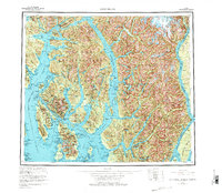
1955 Map of Ketchikan
USGS Topo · Published 1977About this map
Revillagigedo Island serves as the focal point of this coastal survey, dominated by the commercial hub of Ketchikan and the nearby village of Saxman. The intricate shoreline of the Alexander Archipelago is mapped in detail, showing the deep inlets of Behm Canal and Carroll Inlet that define the navigation routes of the mid-twentieth century. To the south, Annette Island hosts the community of Metlakatla, while the eastern portion of the sheet is defined by the United States-Canada border as it runs through the waters of Portland Canal.
Find a feature on this map
42 named features on this map. Tap any name to fly to it.
Don’t see what you’re looking for? This feature index may not catch every label — zoom into the map to look around manually.
Map Details
Editions of this 1955 Ketchikan Map
3 editions found

Other maps of this area

1948 · Petersburg A-1
USGS Topo · 1:63,360

1948 · Prince Rupert D-6
USGS Topo · 1:63,360

1948 · Ketchikan A-6
USGS Topo · 1:63,360

1948 · Craig A-1
USGS Topo · 1:63,360

1948 · Dixon Entrance D-1
USGS Topo · 1:63,360

1948 · Ketchikan C-5
USGS Topo · 1:63,360

1949 · Ketchikan C-6
USGS Topo · 1:63,360

1949 · Ketchikan B-4
USGS Topo · 1:63,360

1949 · Craig B-1
USGS Topo · 1:63,360

1949 · Craig D-1
USGS Topo · 1:63,360