
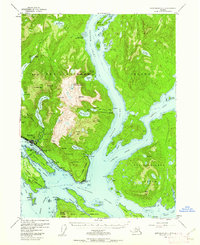
1954 Map of Ketchikan B-5
USGS Topo · Published 1955About this map
The maritime activity of Southeast Alaska is centered on Ketchikan and its position along the Tongass Narrows. This mid-century survey details the industrial infrastructure of the era, from the Cannery and Sawmill to the Beaver Falls Power House, which utilized an aqueduct from Lower Silvis Lake. The landscape is a mix of commercial hub and rugged interior, featuring landmarks like the Mahoney Mine and the White River Boy Scout Camp.
Find a feature on this map
81 named features on this map. Tap any name to fly to it.
Don’t see what you’re looking for? This feature index may not catch every label — zoom into the map to look around manually.
Map Details
Editions of this 1954 Ketchikan B-5 Map
2 editions found
Other maps of this area

1948 · Ketchikan A-6
USGS Topo · 1:63,360

1948 · Ketchikan C-5
USGS Topo · 1:63,360

1949 · Ketchikan C-6
USGS Topo · 1:63,360

1949 · Ketchikan B-4
USGS Topo · 1:63,360

1952 · Ketchikan
USGS Topo · 1:250,000

1952 · Ketchikan B-4
USGS Topo · 1:63,360

1952 · Ketchikan C-4
USGS Topo · 1:63,360

1952 · Ketchikan C-6
USGS Topo · 1:63,360

1953 · Ketchikan C-5
USGS Topo · 1:63,360

1953 · Ketchikan B-6
USGS Topo · 1:63,360