
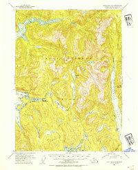
1953 Map of Ketchikan C-5
USGS Topo · Published 1954About this map
Revillagigedo Island presents a complex network of waterways and glacial topography in this mid-century topographic record. The settlement of Loring on Naha Bay serves as a primary coastal anchor, while further inland, the Orton Ranch and Black Bear Observation Post indicate seasonal human presence within the Tongass National Forest. A notable detail of the local resource history is the Fish Hatchery (Aban'd) located near Heckman Lake, signifying a shift in the region's fisheries management at the time of the survey. The landscape is defined by deep fjords like Carroll Inlet and George Inlet, and unique tidal features such as Roosevelt Lagoon and its corresponding Tiderace. High-elevation lakes, including Orton Lake and Snow Lake, dot the interior, feeding into systems like the Naha River and Carroll Creek.
Find a feature on this map
35 named features on this map. Tap any name to fly to it.
Don’t see what you’re looking for? This feature index may not catch every label — zoom into the map to look around manually.
Map Details
Editions of this 1953 Ketchikan C-5 Map
2 editions found
Other maps of this area

1948 · Ketchikan C-5
USGS Topo · 1:63,360

1949 · Ketchikan C-6
USGS Topo · 1:63,360

1949 · Ketchikan B-4
USGS Topo · 1:63,360

1952 · Ketchikan
USGS Topo · 1:250,000

1952 · Ketchikan B-4
USGS Topo · 1:63,360

1952 · Ketchikan C-4
USGS Topo · 1:63,360

1952 · Ketchikan C-6
USGS Topo · 1:63,360

1952 · Ketchikan D-5
USGS Topo · 1:63,360

1952 · Ketchikan D-6
USGS Topo · 1:63,360

1953 · Ketchikan B-6
USGS Topo · 1:63,360