Old Maps of Point Baker, Alaska for Academic Research
Study the evolution of Point Baker with 7 high-resolution historic maps. Whether you're teaching, researching, or modeling changes in land use, these maps provide essential visual documentation of urban, environmental, and geographic change.
- Analyze long-term change: Track patterns in development, transportation, and natural features.
- Ideal for environmental or urban studies: Support academic projects with primary historical map data.
- Use in the classroom or lab: Educators and researchers rely on these maps to bring historical context to life.
These maps are a powerful tool for teaching, research, and visualizing how Point Baker has changed over the decades.
Point Baker, AK maps
(7)- 1949 Map of Petersburg B-5, 1963 Print
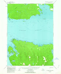 1949 Petersburg B-51963 Print · USGSPrince of Wales and Kupreanof Islands are shown in the mid-twentieth century as maritime life centers on these intricate straits. Trace old coastal activity at the Trading Post near Point Baker and explore the waters of Port Protection.3 unique versions available
 - 1952 Map of Petersburg, 1953 Print
 1952 Petersburg1953 Print · USGSSoutheast Alaska's intricate Alexander Archipelago comes to life in the early fifties, documenting a landscape of remote island settlements and maritime corridors. Genealogists and historians can trace coastal life in Petersburg and Wrangell, or locate early industry at Shakan and regional Mines.5 unique versions available
 - 1953 Map of Petersburg B-5, 1954 Print
 1953 Petersburg B-51954 Print · USGSThe Alexander Archipelago in the early fifties reveals a landscape of isolated maritime outposts and deep coastal inlets. Researchers can trace the early layout of Point Baker and find historic sites like the Trading Post at Wooden Wheel Cove and Port Protection.2 unique versions available
 - 1960 Map of Petersburg, 1966 Print
 1960 Petersburg1966 Print · USGSSoutheast Alaska's maritime landscape is captured here in the mid-1900s, showcasing the intricate island networks of the Alexander Archipelago. Researchers can trace historic shorelines and island settlements from Petersburg and Kake to the Wrangell Cemetery and the Stikine River.3 unique versions available
 - 1995 Map of Petersburg B-5, 1999 Print
 1995 Petersburg B-51999 Print · USGSPrince of Wales Island and Kupreanof Island are shown in the mid-nineties during a period of active timber management and coastal settlement. Researchers can trace the layout of the Logging Camp and Log Transfer Facility near Port Protection and the small harbor at Point Baker.
 - 2017 Map of Petersburg B-5 SW, 2017 Print
 2017 Petersburg B-5 SW2017 Print · USGSCovers Point Baker, including Labouchere Bay, Port Protection, and other nearby areas
 - 2021 Map of Petersburg B-5 SW, 2021 Print
 2021 Petersburg B-5 SW2021 Print · USGSThe northern reaches of Prince of Wales Island come into focus in this recent survey of the Alaska panhandle. Researchers can trace the waterfront layouts of Point Baker and Port Protection or follow forest trails near Labouchere Bay.
End of results
Showing maps 1-7 of 7
Frequently asked questions
- What are the different types of historical maps available for Point Baker?
- What is the oldest map of Point Baker?
- Where can I purchase historical maps of Point Baker for my home or office?
- Where can I download high-res historical maps of Point Baker?
- Are there historical topographic maps available for Point Baker?
- Is there historical aerial imagery available for Point Baker?
- Where are historical maps of Point Baker sourced from?