Old Maps of Port Protection, Alaska
Explore 7 old maps of Port Protection, spanning from 1949 to today. These high-resolution historic maps reveal how streets, neighborhoods, landmarks, and natural features evolved over time — perfect for genealogy, metal detecting, research, and local history exploration.
What you can do with these maps:
- See how Port Protection changed over time: Compare historical maps to modern-day views to trace roads, homesites, rail lines & more.
- View detailed metadata: Each map includes creators, publishers, year, scale, and archive source.
- Overlay maps with satellite & LiDAR: Visualize the past alongside modern tools to explore terrain & human change.
- Trusted historical sources: Maps sourced from the USGS, Library of Congress, and other archives.
- Access maps your way: View online, download high-res files, or order prints for personal or research use.
Start exploring old maps of Port Protection to uncover forgotten places, hidden landmarks, and the deep history beneath your feet.
Port Protection, AK maps
(7)- 1949 Map of Petersburg B-5, 1963 Print
 1949 Petersburg B-51963 Print · USGSPrince of Wales and Kupreanof Islands are shown in the mid-twentieth century as maritime life centers on these intricate straits. Trace old coastal activity at the Trading Post near Point Baker and explore the waters of Port Protection.3 unique versions available
 - 1952 Map of Petersburg, 1953 Print
 1952 Petersburg1953 Print · USGSSoutheast Alaska's intricate Alexander Archipelago comes to life in the early fifties, documenting a landscape of remote island settlements and maritime corridors. Genealogists and historians can trace coastal life in Petersburg and Wrangell, or locate early industry at Shakan and regional Mines.5 unique versions available
 - 1953 Map of Petersburg B-5, 1954 Print
 1953 Petersburg B-51954 Print · USGSThe Alexander Archipelago in the early fifties reveals a landscape of isolated maritime outposts and deep coastal inlets. Researchers can trace the early layout of Point Baker and find historic sites like the Trading Post at Wooden Wheel Cove and Port Protection.2 unique versions available
 - 1960 Map of Petersburg, 1966 Print
 1960 Petersburg1966 Print · USGSSoutheast Alaska's maritime landscape is captured here in the mid-1900s, showcasing the intricate island networks of the Alexander Archipelago. Researchers can trace historic shorelines and island settlements from Petersburg and Kake to the Wrangell Cemetery and the Stikine River.3 unique versions available
 - 1995 Map of Petersburg B-5, 1999 Print
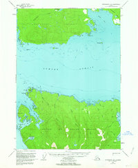
 1995 Petersburg B-51999 Print · USGSPrince of Wales Island and Kupreanof Island are shown in the mid-nineties during a period of active timber management and coastal settlement. Researchers can trace the layout of the Logging Camp and Log Transfer Facility near Port Protection and the small harbor at Point Baker.
 - 2017 Map of Petersburg B-5 SW, 2017 Print
 2017 Petersburg B-5 SW2017 Print · USGSCovers Port Protection, including Labouchere Bay, Point Baker, and other nearby areas
 - 2021 Map of Petersburg B-5 SW, 2021 Print
 2021 Petersburg B-5 SW2021 Print · USGSThe northern reaches of Prince of Wales Island come into focus in this recent survey of the Alaska panhandle. Researchers can trace the waterfront layouts of Point Baker and Port Protection or follow forest trails near Labouchere Bay.
End of results
Showing maps 1-7 of 7
Frequently asked questions
- What are the different types of historical maps available for Port Protection?
- What is the oldest map of Port Protection?
- Where can I purchase historical maps of Port Protection for my home or office?
- Where can I download high-res historical maps of Port Protection?
- Are there historical topographic maps available for Port Protection?
- Is there historical aerial imagery available for Port Protection?
- Where are historical maps of Port Protection sourced from?