1950s Maps of Liarsville Gold Rush Trail Camp & Salmon Bake, Alaska
Explore 2 historic maps of Liarsville Gold Rush Trail Camp & Salmon Bake from the 1950s. These maps offer a rare glimpse into what life looked like during the 1950s — showing old roads, neighborhoods, homes, and landmarks that have changed or disappeared over time.
Whether you're researching your family's past, planning a metal detecting trip, or studying how Liarsville Gold Rush Trail Camp & Salmon Bake's landscape evolved across the 1950s, these high-resolution maps are a powerful tool for exploring the history of this region.
- Focus on a specific era: All maps on this page are from the 1950s, giving you a focused view of this time period.
- See what’s changed: Compare century-old streets, trails, and buildings to today's modern landscape using overlays and satellite layers.
- Research with precision: Use these maps for genealogy, historical research, land use analysis, or educational projects.
- View, download, or print: Maps are fully viewable online in high resolution, and can be downloaded or printed for your own records.
Start exploring Liarsville Gold Rush Trail Camp & Salmon Bake's history through authentic maps from the 1950s. This is your window into the past.
Liarsville Gold Rush Trail Camp & Salmon Bake, AK maps
(2)- 1951 Map of Skagway B-1, 1952 Print
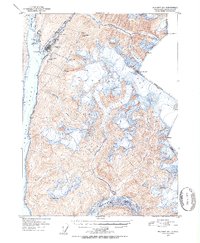 1951 Skagway B-11952 Print · USGSSkagway and the head of Taiya Inlet are captured here in the early 1950s as a vital transportation hub. Trace the White Pass and Yukon Route and find local landmarks like Reid Falls, Lower Dewey Lake, and the town Powder House.2 unique versions available
 - 1952 Map of Skagway, 1953 Print
 1952 Skagway1953 Print · USGSThe northern reaches of the Alaska Panhandle come alive in the early fifties, showing the vital rail and road links to the Yukon. Trace the historic White Pass & Yukon Route or locate remote camps like Pleasant Camp and Klukwan.4 unique versions available
End of results
Showing maps 1-2 of 2
Top cities near Liarsville Gold Rush Trail Camp & Salmon Bake
Frequently asked questions
- What are the different types of historical maps available for Liarsville Gold Rush Trail Camp & Salmon Bake?
- What is the oldest map of Liarsville Gold Rush Trail Camp & Salmon Bake?
- Where can I purchase historical maps of Liarsville Gold Rush Trail Camp & Salmon Bake for my home or office?
- Where can I download high-res historical maps of Liarsville Gold Rush Trail Camp & Salmon Bake?
- Are there historical topographic maps available for Liarsville Gold Rush Trail Camp & Salmon Bake?
- Is there historical aerial imagery available for Liarsville Gold Rush Trail Camp & Salmon Bake?
- Where are historical maps of Liarsville Gold Rush Trail Camp & Salmon Bake sourced from?