1900s (20th Century) Maps of Alexanders Village, Alaska
Explore 4 historic maps of Alexanders Village from the 1900s (20th Century). These maps offer a rare glimpse into what life looked like during the 1900s — showing old roads, neighborhoods, homes, and landmarks that have changed or disappeared over time.
Whether you're researching your family's past, planning a metal detecting trip, or studying how Alexanders Village's landscape evolved across the 1900s, these high-resolution maps are a powerful tool for exploring the history of this region.
- Focus on a specific era: All maps on this page are from the 1900s, giving you a focused view of this time period.
- See what’s changed: Compare century-old streets, trails, and buildings to today's modern landscape using overlays and satellite layers.
- Research with precision: Use these maps for genealogy, historical research, land use analysis, or educational projects.
- View, download, or print: Maps are fully viewable online in high resolution, and can be downloaded or printed for your own records.
Start exploring Alexanders Village's history through authentic maps from the 1900s. This is your window into the past.
Alexanders Village, AK maps
(4)- 1951 Map of Fort Yukon
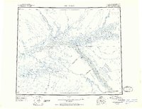 1951 Fort Yukon1951 Print · USGSThe Yukon Flats and the crossing of the Arctic Circle define this region during the early fifties. Researchers can trace seasonal wilderness routes like the Winter Trail and locate remote outposts from Venetie Landing to White Eye.
 - 1955 Map of Fort Yukon D-3, 1958 Print
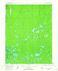
 1955 Fort Yukon D-31958 Print · USGSThe northern Alaskan interior within the Venetie Indian Reservation is captured here during the mid-fifties. Researchers can trace seasonal transport routes like the Sled Trail (Approximate) and locate the riverside settlement of Alexanders Village.
 - 1956 Map of Fort Yukon, 1960 Print
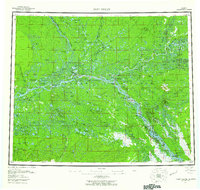 1956 Fort Yukon1960 Print · USGSThe Yukon Flats and the Gwich'in homelands are captured here in the mid-fifties, centered on the historic river trading hub at Fort Yukon. Trace the seasonal routes of the interior via Winter Trail networks and locate isolated family landmarks like Bearman Cabin and Alexander Village.7 unique versions available
 - 1956 Map of Fort Yukon D-3, 1964 Print
 1956 Fort Yukon D-31964 Print · USGSThe northern Yukon Flats in the mid-1950s centered on the Venetie Indian Reservation and its river-dependent lifeways. Genealogists and historians can trace the location of Alexanders Village and the traditional Winter Trail.2 unique versions available
End of results
Showing maps 1-4 of 4
Top cities near Alexanders Village
Frequently asked questions
- What are the different types of historical maps available for Alexanders Village?
- What is the oldest map of Alexanders Village?
- Where can I purchase historical maps of Alexanders Village for my home or office?
- Where can I download high-res historical maps of Alexanders Village?
- Are there historical topographic maps available for Alexanders Village?
- Is there historical aerial imagery available for Alexanders Village?
- Where are historical maps of Alexanders Village sourced from?