Old Maps of Alexanders Village, Alaska for Hiking & Exploration
Hike through history with 5 historic maps of Alexanders Village. Explore old trails, ghost towns, and forgotten backroads — perfect for outdoor adventurers and local explorers.
- Rediscover forgotten places: Map out old mining camps, roads, and footpaths that no longer exist on modern maps.
- Layer with modern tools: Combine with LiDAR or satellite views to plan hikes through historical terrain.
- Made for exploration: Popular among hikers, overlanders, and local history lovers.
Use these maps to find adventure and explore the hidden past of Alexanders Village.
Alexanders Village, AK maps
(5)- 1951 Map of Fort Yukon
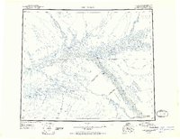 1951 Fort Yukon1951 Print · USGSThe Yukon Flats and the crossing of the Arctic Circle define this region during the early fifties. Researchers can trace seasonal wilderness routes like the Winter Trail and locate remote outposts from Venetie Landing to White Eye.
 - 1955 Map of Fort Yukon D-3, 1958 Print
 1955 Fort Yukon D-31958 Print · USGSThe northern Alaskan interior within the Venetie Indian Reservation is captured here during the mid-fifties. Researchers can trace seasonal transport routes like the Sled Trail (Approximate) and locate the riverside settlement of Alexanders Village.
 - 1956 Map of Fort Yukon, 1960 Print
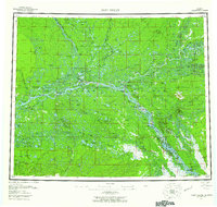 1956 Fort Yukon1960 Print · USGSThe Yukon Flats and the Gwich'in homelands are captured here in the mid-fifties, centered on the historic river trading hub at Fort Yukon. Trace the seasonal routes of the interior via Winter Trail networks and locate isolated family landmarks like Bearman Cabin and Alexander Village.7 unique versions available
 - 1956 Map of Fort Yukon D-3, 1964 Print
 1956 Fort Yukon D-31964 Print · USGSThe northern Yukon Flats in the mid-1950s centered on the Venetie Indian Reservation and its river-dependent lifeways. Genealogists and historians can trace the location of Alexanders Village and the traditional Winter Trail.2 unique versions available
 - 2018 Map of Fort Yukon D-3 SW, 2018 Print
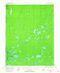
 2018 Fort Yukon D-3 SW2018 Print · USGSThe Yukon-Koyukuk interior in the late twenty-teens remains a landscape of intricate wetlands and river networks. Researchers can locate Alexanders Village and trace the winding course of the Christian River past landmarks like Shotuih Hill and Shovun Lake.
End of results
Showing maps 1-5 of 5
Top cities near Alexanders Village
Frequently asked questions
- What are the different types of historical maps available for Alexanders Village?
- What is the oldest map of Alexanders Village?
- Where can I purchase historical maps of Alexanders Village for my home or office?
- Where can I download high-res historical maps of Alexanders Village?
- Are there historical topographic maps available for Alexanders Village?
- Is there historical aerial imagery available for Alexanders Village?
- Where are historical maps of Alexanders Village sourced from?