Old Maps of Anogok, Alaska for Metal Detecting
Plan your next treasure hunt with 4 historic maps of Anogok. Find old homesites, ghost towns, trails, and gathering spots that may be lost to time — perfect for identifying promising metal detecting locations.
- Locate forgotten sites: Uncover places like long-lost settlements, abandoned rail lines, or gathering spots.
- Plan better hunts: Use map overlays combined with LiDAR or satellite views to narrow in on historically rich areas.
- Made for detectorists: Thousands of hobbyists use these maps to discover relics, coins, and hidden history.
Use these historic maps to boost your research and find new opportunities beneath the surface of Anogok.
Anogok, AK maps
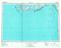
(4)- 1951 Map of Kuskokwim Bay
 1951 Kuskokwim Bay1951 Print · USGSThe coastal margins of the Bering Sea in the mid-century reveal a world of isolated settlements and river mouths. Researchers can trace the layout of Kwinhagak, Kipnuk, and Kongiganak along the reaches of Kuskokwim Bay and the Kanektok River.
 - 1954 Map of Kuskokwim Bay, 1967 Print
 1954 Kuskokwim Bay1967 Print · USGSCoastal life in western Alaska during the mid-fifties centered on river mouths and tundra lakes. Researchers can trace remote settlements like Kipnuk and Kongiganak or locate the Seaplane Anchorage used for essential regional transit.3 unique versions available
 - 1954 Map of Kuskokwim Bay D-6, 1971 Print
 1954 Kuskokwim Bay D-61971 Print · USGSCoastal Alaska in the late fifties and early seventies reveals a landscape of shifting tides and remote outposts. Trace the early layout of Kipnuk and Anogok, and locate the essential Seaplane Anchorage near the Kuguklik River.
 - 2020 Map of Kuskokwim Bay D-6 SE, 2020 Print
 2020 Kuskokwim Bay D-6 SE2020 Print · USGSCoastal wetlands and the edge of the Bering Sea define this portion of the Bethel Census Area as it appeared in recent years. Researchers can trace the path of the Anohwahk River as it reaches the coast near Anogok and Kuskokwim Bay.
End of results
Showing maps 1-4 of 4
Frequently asked questions
- What are the different types of historical maps available for Anogok?
- What is the oldest map of Anogok?
- Where can I purchase historical maps of Anogok for my home or office?
- Where can I download high-res historical maps of Anogok?
- Are there historical topographic maps available for Anogok?
- Is there historical aerial imagery available for Anogok?
- Where are historical maps of Anogok sourced from?