Old Maps of Beaver, Alaska for Academic Research
Study the evolution of Beaver with 6 high-resolution historic maps. Whether you're teaching, researching, or modeling changes in land use, these maps provide essential visual documentation of urban, environmental, and geographic change.
- Analyze long-term change: Track patterns in development, transportation, and natural features.
- Ideal for environmental or urban studies: Support academic projects with primary historical map data.
- Use in the classroom or lab: Educators and researchers rely on these maps to bring historical context to life.
These maps are a powerful tool for teaching, research, and visualizing how Beaver has changed over the decades.
Beaver, AK maps
(6)- 1951 Map of Fort Yukon
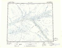 1951 Fort Yukon1951 Print · USGSThe Yukon Flats and the crossing of the Arctic Circle define this region during the early fifties. Researchers can trace seasonal wilderness routes like the Winter Trail and locate remote outposts from Venetie Landing to White Eye.
 - 1956 Map of Fort Yukon B-6, 1959 Print
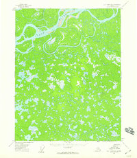 1956 Fort Yukon B-61959 Print · USGSThe Yukon flats come to life in this mid-century survey of the river's winding northern reaches. Researchers can trace the riverbank site of White Eye Village and identify remote locations like Beaver Creek or the junction at Lower Mouth Birch Creek.3 unique versions available
 - 1956 Map of Fort Yukon, 1960 Print
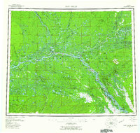 1956 Fort Yukon1960 Print · USGSThe Yukon Flats and the Gwich'in homelands are captured here in the mid-fifties, centered on the historic river trading hub at Fort Yukon. Trace the seasonal routes of the interior via Winter Trail networks and locate isolated family landmarks like Bearman Cabin and Alexander Village.7 unique versions available
 - 1956 Map of Fort Yukon C-6, 1966 Print
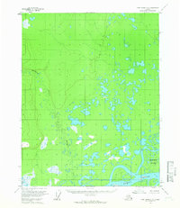 1956 Fort Yukon C-61966 Print · USGSThe Yukon River interior was a maze of wetlands and seasonal waterways in the mid-fifties. Researchers can trace the winding Hadweenzic River, locate a remote Cabin, and study the shifting banks of Deadman Island.2 unique versions available
 - 2018 Map of Fort Yukon B-6 NW, 2018 Print
 2018 Fort Yukon B-6 NW2018 Print · USGSThe Yukon Flats are captured here in the late twenty-teens, showcasing a complex wilderness of braided waterways and sub-arctic wetlands. Researchers can trace the shifting course of the Yukon River, the mouth of the Hadweenzic River, and the winding Lower Birch Creek Slough.
 - 2020 Map of Fort Yukon C-6 SW, 2020 Print
 2020 Fort Yukon C-6 SW2020 Print · USGSAlaska's interior wilderness is captured in the modern era, showing the intricate hydrology of the Yukon-Koyukuk region. Researchers can trace the winding course of the Hadweenzic River through the heart of the T20N R4E land survey.
End of results
Showing maps 1-6 of 6
Frequently asked questions
- What are the different types of historical maps available for Beaver?
- What is the oldest map of Beaver?
- Where can I purchase historical maps of Beaver for my home or office?
- Where can I download high-res historical maps of Beaver?
- Are there historical topographic maps available for Beaver?
- Is there historical aerial imagery available for Beaver?
- Where are historical maps of Beaver sourced from?