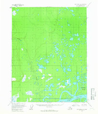
1956 Map of Fort Yukon C-6
USGS Topo · Published 1966About this map
The Yukon River dominates the southern reaches of this mid-century interior Alaska landscape, weaving through a complex network of wetlands and seasonal ponds. The terrain is characterized by the meandering path of the Hadweenzic River, which flows south toward its confluence with the larger Yukon. A lone Cabin sits positioned near the riverbank, serving as a rare marker of human presence in a territory largely defined by its intricate hydrological patterns and shifting river islands. The prominent Deadman Island stands within the main channel of the Yukon, illustrating the constant movement of silt and water that shapes the local geography. Photogrammetric methods from 1955 aerial photography reveal a vast expanse of low-relief swamps and small lakes, providing a detailed record of the drainage basin before significant modern environmental shifts.
Find a feature on this map
4 named features on this map. Tap any name to fly to it.
Don’t see what you’re looking for? This feature index may not catch every label — zoom into the map to look around manually.
Map Details
Editions of this 1956 Fort Yukon C-6 Map
2 editions found
Other maps of this area

1951 · Fort Yukon
USGS Topo · 1:250,000

1951 · Beaver
USGS Topo · 1:250,000

1955 · Fort Yukon D-5
USGS Topo · 1:63,360

1955 · Fort Yukon C-5
USGS Topo · 1:63,360

1956 · Fort Yukon B-6
USGS Topo · 1:63,360

1956 · Beaver
USGS Topo · 1:250,000

1956 · Fort Yukon C-5
USGS Topo · 1:63,360

1956 · Beaver B-1
USGS Topo · 1:63,360

1956 · Fort Yukon B-5
USGS Topo · 1:63,360

1956 · Fort Yukon
USGS Topo · 1:250,000