
1956 Map of Fort Yukon C-5
USGS Topo · Published 1959About this map
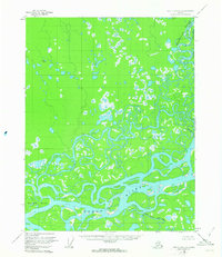
Yukon River waters dominate this mid-century landscape, where a complex network of wetlands and side channels defines the interior Alaskan wilderness. The map captures a moment in the 1950s when human presence was sparse but distinct, marked by specific landmarks like Johnnie the Frog Cabin near Willow Pt. The convergence of major waterways is the primary geographic driver here, with the Chandalar River winding through the northern portion and the Upper Mouth Birch Creek entering from the south. The eastern boundary is defined by the Venetie Indian Reservation, indicating significant land management divisions in this era. Navigational landmarks like Deadman Island and the meandering path of Crazy Slough illustrate the fluid, ever-changing nature of the river valley before modern infrastructure intervened.
Find a feature on this map
11 named features on this map. Tap any name to fly to it.
Don’t see what you’re looking for? This feature index may not catch every label — zoom into the map to look around manually.
Map Details
Editions of this 1956 Fort Yukon C-5 Map
2 editions found
Other maps of this area

1951 · Fort Yukon
USGS Topo · 1:250,000

1952 · Fort Yukon C-4
USGS Topo · 1:63,360

1955 · Fort Yukon D-4
USGS Topo · 1:63,360

1955 · Fort Yukon D-5
USGS Topo · 1:63,360

1955 · Fort Yukon C-5
USGS Topo · 1:63,360

1956 · Fort Yukon B-6
USGS Topo · 1:63,360

1956 · Fort Yukon B-4
USGS Topo · 1:63,360

1956 · Fort Yukon B-5
USGS Topo · 1:63,360

1956 · Fort Yukon
USGS Topo · 1:250,000
1956 · Fort Yukon C-4
USGS Topo · 1:63,360