
1956 Map of Fort Yukon B-4
USGS Topo · Published 1959About this map
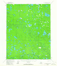
The intricate wetland landscape of the Yukon-Koyukuk region is defined by the winding course of Birch Creek as it branches into the Upper Mouth Birch Creek and Lower Mouth Birch Creek. This 1956 field-annotated survey reveals a complex network of thermokarst lakes and seasonal waterways characteristic of the Alaskan interior. A single Winter Trail provides a glimpse into the historic overland travel routes that crossed these marshes before the spring thaw rendered the terrain impassable. Larger named bodies of water like Twelvemile Lake and Hatlie Lakes stand out against the densely patterned marshlands, while secondary streams such as Tajittro Creek and Discovery Creek feed into the primary drainage system. The presence of the VABM 420 Bugs triangulation station indicates the precise surveying efforts required to map this labyrinthine aquatic environment.
Find a feature on this map
11 named features on this map. Tap any name to fly to it.
Don’t see what you’re looking for? This feature index may not catch every label — zoom into the map to look around manually.
Map Details
Editions of this 1956 Fort Yukon B-4 Map
2 editions found
Other maps of this area

1951 · Fort Yukon
USGS Topo · 1:250,000

1952 · Fort Yukon C-3
USGS Topo · 1:63,360

1952 · Fort Yukon C-4
USGS Topo · 1:63,360

1955 · Fort Yukon C-3
USGS Topo · 1:63,360

1955 · Fort Yukon C-5
USGS Topo · 1:63,360

1956 · Fort Yukon A-4
USGS Topo · 1:63,360

1956 · Fort Yukon B-3
USGS Topo · 1:63,360

1956 · Fort Yukon C-5
USGS Topo · 1:63,360

1956 · Fort Yukon A-5
USGS Topo · 1:63,360
1956 · Fort Yukon A-3
USGS Topo · 1:63,360