
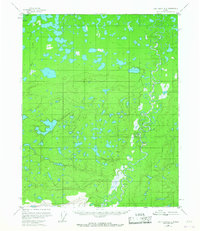
1956 Map of Fort Yukon A-5
USGS Topo · Published 1959About this map
Beaver Creek meanders sharply through the eastern half of this interior Alaskan landscape, characterized by a complex network of wetlands and muskeg. Mapped in the mid-1950s using aerial photography, the terrain is dominated by hundreds of unnamed thermokarst lakes and ponds typical of the Yukon Flats region. Evidence of human presence is sparse, marked only by isolated structures such as a solitary Cabin and another identified as Cabin (Aban'd) near the riverbanks. In the northwest corner, Big Creek flows through a dense collection of water bodies, illustrating the fluid and ever-changing drainage patterns of this subarctic environment. The lack of roads or established trails highlights the reliance on waterways for travel and subsistence during this era.
Find a feature on this map
4 named features on this map. Tap any name to fly to it.
Don’t see what you’re looking for? This feature index may not catch every label — zoom into the map to look around manually.
Map Details
Editions of this 1956 Fort Yukon A-5 Map
2 editions found
Other maps of this area

1951 · Fort Yukon
USGS Topo · 1:250,000

1951 · Circle
USGS Topo · 1:250,000

1951 · Circle D-6
USGS Topo · 1:63,360

1952 · Circle D-4
USGS Topo · 1:63,360

1952 · Circle D-5
USGS Topo · 1:63,360

1954 · Circle D-5
USGS Topo · 1:63,360

1954 · Circle D-6
USGS Topo · 1:63,360

1955 · Circle
USGS Topo · 1:250,000

1956 · Fort Yukon B-6
USGS Topo · 1:63,360

1956 · Fort Yukon B-4
USGS Topo · 1:63,360