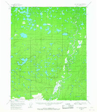
1956 Map of Fort Yukon A-5
USGS Topo · Published 1967About this map
The winding waters of Beaver Creek and Big Beaver Creek dominate this landscape in the Yukon-Koyukuk region. Surveyed in the mid-1950s using aerial photography, the map reveals an intricate network of oxbow lakes, wetlands, and small unnamed ponds that define the drainage basins of the Interior. While largely an uninhabited wilderness of shifting watercourses, the presence of a Cabin (Aban'd) and a second Cabin provides a rare trace of human activity, likely linked to trapping or seasonal travel. The complex topography shown here is characteristic of the low-lying flats, where the river's movement over time has created a labyrinth of sloughs and cutoffs.
Find a feature on this map
4 named features on this map. Tap any name to fly to it.
Don’t see what you’re looking for? This feature index may not catch every label — zoom into the map to look around manually.
Map Details
Editions of this 1956 Fort Yukon A-5 Map
2 editions found

Other maps of this area

1951 · Fort Yukon
USGS Topo · 1:250,000

1951 · Circle
USGS Topo · 1:250,000

1951 · Circle D-6
USGS Topo · 1:63,360

1952 · Circle D-4
USGS Topo · 1:63,360

1952 · Circle D-5
USGS Topo · 1:63,360

1954 · Circle D-5
USGS Topo · 1:63,360

1954 · Circle D-6
USGS Topo · 1:63,360

1955 · Circle
USGS Topo · 1:250,000

1956 · Fort Yukon B-6
USGS Topo · 1:63,360

1956 · Fort Yukon B-4
USGS Topo · 1:63,360