
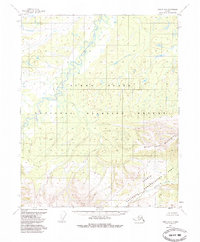
1952 Map of Circle D-5
USGS Topo · Published 1972About this map
Beaver Creek winds through the northern interior of Alaska in this mid-century topographic record, showcasing a landscape defined by dramatic elevation changes and intricate fluvial patterns. The map area is dominated by the complex, meandering path of the river as it cuts through the terrain, flanked by numerous small lakes and ponds in the low-lying northern section. To the south, the topography shifts abruptly into the high ridges where Preacher Creek and the North Fork originate. This 1952 documentation, with minor revisions in 1971, captures a period when the Bureau of Land Management used predetermined locations for unsurveyed land lines. The absence of roads or established settlements emphasizes the wilderness character of the region, where the primary geographical markers are the watercourses that have shaped the land over centuries.
Find a feature on this map
3 named features on this map. Tap any name to fly to it.
Don’t see what you’re looking for? This feature index may not catch every label — zoom into the map to look around manually.
Map Details
Editions of this 1952 Circle D-5 Map
2 editions found
Other maps of this area

1951 · Fort Yukon
USGS Topo · 1:250,000

1951 · Circle
USGS Topo · 1:250,000

1951 · Circle D-6
USGS Topo · 1:63,360

1951 · Circle C-6
USGS Topo · 1:63,360

1952 · Circle D-4
USGS Topo · 1:63,360

1952 · Circle C-4
USGS Topo · 1:63,360

1952 · Circle C-5
USGS Topo · 1:63,360

1954 · Circle C-5
USGS Topo · 1:63,360

1954 · Circle D-5
USGS Topo · 1:63,360

1954 · Circle D-6
USGS Topo · 1:63,360