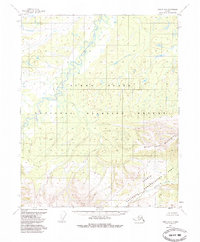
1952 Map of Circle D-5
USGS Topo · Published 1985About this map
Beaver Creek meanders through the heart of this Alaskan landscape, illustrating the complex hydrology of the Yukon Flats in the early 1950s. The northern portion of the map is dominated by the sprawling lowlands of the Yukon Flats National Wildlife Refuge, a region characterized by countless small ponds and oxbows typical of an active flood basin. Moving southward, the elevation rises sharply into the West Crazy Mountains, creating a stark transition from river bottom to high-altitude relief.
Find a feature on this map
6 named features on this map. Tap any name to fly to it.
Don’t see what you’re looking for? This feature index may not catch every label — zoom into the map to look around manually.
Map Details
Editions of this 1952 Circle D-5 Map
2 editions found
Other maps of this area

1951 · Fort Yukon
USGS Topo · 1:250,000

1951 · Circle
USGS Topo · 1:250,000

1951 · Circle D-6
USGS Topo · 1:63,360

1951 · Circle C-6
USGS Topo · 1:63,360

1952 · Circle D-4
USGS Topo · 1:63,360

1952 · Circle C-4
USGS Topo · 1:63,360

1952 · Circle D-5
USGS Topo · 1:63,360

1952 · Circle C-5
USGS Topo · 1:63,360

1954 · Circle C-5
USGS Topo · 1:63,360

1954 · Circle D-5
USGS Topo · 1:63,360