
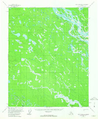
1956 Map of Fort Yukon B-3
USGS Topo · Published 1959About this map
The Yukon River carves a complex path through this subarctic terrain, joined by a dense network of waterways including Seventeenmile Slough and Yabm Slough. This 1950s survey documents a landscape of shifting channels and low-lying islands, such as Twelvemile Island and Egil Island. The geography is defined by a heavy concentration of wetlands and lakes, with Ninemile Lake situated in the northern reaches of the quadrangle. Human presence is sparse, marked primarily by a single Cabin along the winding course of Birch Creek and a solitary Winter Trail cutting through the northwestern section. These features suggest a seasonal reliance on the landscape for trapping or subsistence, typical of the interior before more permanent infrastructure reached this part of the Yukon-Koyukuk region. Mapping control was provided by the U.S. Geological Survey and USC&GS, utilizing aerial photography to document the intricate drainage patterns.
Find a feature on this map
11 named features on this map. Tap any name to fly to it.
Don’t see what you’re looking for? This feature index may not catch every label — zoom into the map to look around manually.
Map Details
Editions of this 1956 Fort Yukon B-3 Map
2 editions found
Other maps of this area

1951 · Fort Yukon
USGS Topo · 1:250,000

1952 · Fort Yukon C-2
USGS Topo · 1:63,360

1952 · Fort Yukon C-3
USGS Topo · 1:63,360

1952 · Fort Yukon C-4
USGS Topo · 1:63,360

1955 · Fort Yukon C-3
USGS Topo · 1:63,360

1956 · Fort Yukon B-4
USGS Topo · 1:63,360

1956 · Fort Yukon A-2
USGS Topo · 1:63,360

1956 · Fort Yukon A-4
USGS Topo · 1:63,360

1956 · Fort Yukon B-2
USGS Topo · 1:63,360
1956 · Fort Yukon A-3
USGS Topo · 1:63,360