
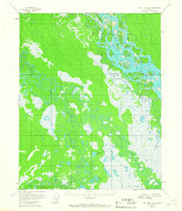
1956 Map of Fort Yukon A-2
USGS Topo · Published 1959About this map
The Yukon River dominates this interior Alaska landscape, weaving through a complex network of braided channels and shifting bars. During the mid-1950s, the river's dynamic nature is evidenced by features like Saloon Island and the descriptive Halfway Whirlpool. The surrounding lowlands are defined by the intricate meandering of Birch Creek and Preacher Creek, which create a dense pattern of oxbows and marshy terrain typical of the Yukon Flats.
Find a feature on this map
10 named features on this map. Tap any name to fly to it.
Don’t see what you’re looking for? This feature index may not catch every label — zoom into the map to look around manually.
Map Details
Editions of this 1956 Fort Yukon A-2 Map
2 editions found
Other maps of this area

1951 · Fort Yukon
USGS Topo · 1:250,000

1951 · Circle
USGS Topo · 1:250,000

1952 · Circle D-3
USGS Topo · 1:63,360

1952 · Circle D-2
USGS Topo · 1:63,360

1955 · Circle D-1
USGS Topo · 1:63,360

1955 · Circle
USGS Topo · 1:250,000

1956 · Fort Yukon B-3
USGS Topo · 1:63,360

1956 · Fort Yukon B-1
USGS Topo · 1:63,360

1956 · Fort Yukon A-1
USGS Topo · 1:63,360

1956 · Fort Yukon B-2
USGS Topo · 1:63,360