
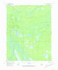
1956 Map of Fort Yukon B-1
USGS Topo · Published 1959About this map
Sucker River snakes through this interior Alaskan landscape, which was mapped from aerial photography taken in the early 1950s. The terrain is characterized by complex wetland patterns and a massive stretch of Grass that dominates the northern half of the quadrangle. This 1956 field study documents a wilderness environment shaped by seasonal hydrological shifts, where the only sign of human passage is a solitary Tractor Trail cutting through the eastern elevations. The survey provides a clear look at the intricate oxbows and marshy lowlands of the Sucker River drainage before modern infrastructure altered the subarctic topography.
Find a feature on this map
3 named features on this map. Tap any name to fly to it.
Don’t see what you’re looking for? This feature index may not catch every label — zoom into the map to look around manually.
Map Details
Editions of this 1956 Fort Yukon B-1 Map
2 editions found
Other maps of this area

1951 · Fort Yukon
USGS Topo · 1:250,000

1951 · Black River
USGS Topo · 1:250,000

1952 · Fort Yukon C-2
USGS Topo · 1:63,360

1956 · Fort Yukon C-1
USGS Topo · 1:63,360

1956 · Black River B-6
USGS Topo · 1:63,360

1956 · Fort Yukon A-2
USGS Topo · 1:63,360

1956 · Black River C-6
USGS Topo · 1:63,360

1956 · Fort Yukon A-1
USGS Topo · 1:63,360

1956 · Fort Yukon B-2
USGS Topo · 1:63,360

1956 · Black River A-6
USGS Topo · 1:63,360