
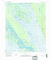
1956 Map of Fort Yukon A-1
USGS Topo · Published 1959About this map
The Yukon River carves a complex path through the interior of Alaska in the late 1950s, defined by a massive network of braided channels and shifting islands. This specific survey area is dominated by the expansive Twentytwo Mile Island, which is separated from the eastern shoreline by the Twentytwo Mile Slough. The presence of a Cabin and the Twentytwo Mile Island Village triangulation station indicates a human footprint along these active waterways, likely serving as seasonal or subsistence sites for river travel. To the east, the landscape transitions from the river's alluvial plain toward higher ground, marked only by a long Tractor Trail that provides a singular overland route through the brush. In the southwest corner, the map shows where Birch Creek nears the main river system, highlighting the intricate drainage patterns of the Yukon Flats region during this era of early aerial photogrammetry.
Find a feature on this map
7 named features on this map. Tap any name to fly to it.
Don’t see what you’re looking for? This feature index may not catch every label — zoom into the map to look around manually.
Map Details
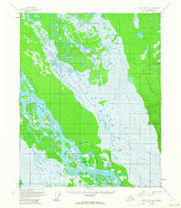
Editions of this 1956 Fort Yukon A-1 Map
3 editions found
Other maps of this area

1951 · Fort Yukon
USGS Topo · 1:250,000

1951 · Charley River
USGS Topo · 1:250,000

1951 · Black River
USGS Topo · 1:250,000

1951 · Circle
USGS Topo · 1:250,000

1952 · Circle D-2
USGS Topo · 1:63,360

1955 · Circle D-1
USGS Topo · 1:63,360

1955 · Circle
USGS Topo · 1:250,000

1956 · Black River B-6
USGS Topo · 1:63,360

1956 · Fort Yukon A-2
USGS Topo · 1:63,360

1956 · Fort Yukon B-1
USGS Topo · 1:63,360