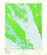
1956 Map of Fort Yukon A-1
USGS Topo · Published 1963About this map
Twentytwo Mile Village stands on the banks of the Yukon River at the heart of this mid-century subarctic survey. The landscape is defined by the braided channels and expansive wetlands surrounding the Twentytwo Mile Slough and the Twentytwo Mile Islands. Human presence is sparse, marked only by an isolated Cabin and the village, reflecting the subsistence-based settlement patterns of the interior. Transportation relies on the seasonal Winter Trail, which cuts across the marshy lowlands, and the natural waterways like Birch Creek. This survey, based on 1952 aerial photography and 1956 field annotation, captures a specific moment in the geography of the Yukon-Koyukuk region before more modern infrastructure began to reach these isolated riverine communities.
Find a feature on this map
8 named features on this map. Tap any name to fly to it.
Don’t see what you’re looking for? This feature index may not catch every label — zoom into the map to look around manually.
Map Details
Editions of this 1956 Fort Yukon A-1 Map
3 editions found

Other maps of this area

1951 · Fort Yukon
USGS Topo · 1:250,000

1951 · Charley River
USGS Topo · 1:250,000

1951 · Black River
USGS Topo · 1:250,000

1951 · Circle
USGS Topo · 1:250,000

1952 · Circle D-2
USGS Topo · 1:63,360

1955 · Circle D-1
USGS Topo · 1:63,360

1955 · Circle
USGS Topo · 1:250,000

1956 · Black River B-6
USGS Topo · 1:63,360

1956 · Fort Yukon A-2
USGS Topo · 1:63,360

1956 · Fort Yukon B-1
USGS Topo · 1:63,360