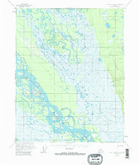
1956 Map of Fort Yukon A-1
USGS Topo · Published 1963About this map
The Yukon River carves a massive, braided path through this interior Alaskan landscape, dominated by a complex network of seasonal waterways and wetlands. In the mid-1950s, human presence was centered on the riverbanks at Twentytwo Mile Village, where a lone Cabin and the VABM Island survey station stand near the confluence of the Twentytwo Mile Slough. The topography is defined by the shifting nature of these alluvial channels, which are bounded by an extensive Winter Trail and an Approximate Winter Trail to the north, suggesting the importance of seasonal overland travel in the absence of permanent roads. Near the southern edge of the sheet, Birch Creek joins the larger river system, highlighting the intersection of multiple drainage basins in this low-lying, swampy territory.
Find a feature on this map
14 named features on this map. Tap any name to fly to it.
Don’t see what you’re looking for? This feature index may not catch every label — zoom into the map to look around manually.
Map Details
Editions of this 1956 Fort Yukon A-1 Map
3 editions found

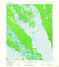
Other maps of this area

1951 · Fort Yukon
USGS Topo · 1:250,000

1951 · Charley River
USGS Topo · 1:250,000

1951 · Black River
USGS Topo · 1:250,000

1951 · Circle
USGS Topo · 1:250,000

1952 · Circle D-2
USGS Topo · 1:63,360

1955 · Circle D-1
USGS Topo · 1:63,360

1955 · Circle
USGS Topo · 1:250,000

1956 · Black River B-6
USGS Topo · 1:63,360

1956 · Fort Yukon A-2
USGS Topo · 1:63,360

1956 · Fort Yukon B-1
USGS Topo · 1:63,360