
1956 Map of Black River A-6
USGS Topo · Published 1959About this map
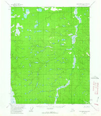
Big Creek defines the eastern corridor of this interior Alaskan landscape, winding through a complex network of wetlands and unnamed lakes during the mid-1950s. The terrain is characterized by a dense concentration of smaller water bodies and significant topographical relief, with numerous unnamed peaks exceeding 800 feet. This 1:63,360 scale survey provides an unblemished look at the region before modern infrastructure, as the margin notes confirm there were no roads or trails present in this area at the time of the 1956 field annotation. The intricate contour work reflects the raw hydrology of the Yukon-Koyukuk region, where the drainage patterns of Big Creek dominate the eastern basin.
Find a feature on this map
1 named feature on this map. Tap any name to fly to it.
Don’t see what you’re looking for? This feature index may not catch every label — zoom into the map to look around manually.
Map Details
Editions of this 1956 Black River A-6 Map
2 editions found
Other maps of this area

1951 · Fort Yukon
USGS Topo · 1:250,000

1951 · Charley River
USGS Topo · 1:250,000

1951 · Black River
USGS Topo · 1:250,000

1951 · Circle
USGS Topo · 1:250,000

1955 · Circle D-1
USGS Topo · 1:63,360

1955 · Circle
USGS Topo · 1:250,000

1956 · Black River B-6
USGS Topo · 1:63,360

1956 · Black River B-5
USGS Topo · 1:63,360

1956 · Fort Yukon B-1
USGS Topo · 1:63,360

1956 · Fort Yukon A-1
USGS Topo · 1:63,360