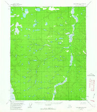
1956 Map of Black River A-6
USGS Topo · Published 1963About this map
Big Creek meanders through this portion of the Yukon-Koyukuk region, defining a landscape dominated by complex drainage patterns and numerous unnamed lakes and ponds. Based on aerial photographs from 1955 and field annotated in 1956, the map documents a wilderness area largely devoid of permanent roads or trails at the time of the survey. The intricate contour lines illustrate a low-lying terrain punctuated by subtle ridges, where the water table is high enough to sustain an extensive network of wetlands. This cartographic study by the Geological Survey captures the territory before modern infrastructure, preserving the original hydrological layout of the Big Creek drainage basin and its surrounding hills.
Find a feature on this map
1 named feature on this map. Tap any name to fly to it.
Don’t see what you’re looking for? This feature index may not catch every label — zoom into the map to look around manually.
Map Details
Editions of this 1956 Black River A-6 Map
2 editions found

Other maps of this area

1951 · Fort Yukon
USGS Topo · 1:250,000

1951 · Charley River
USGS Topo · 1:250,000

1951 · Black River
USGS Topo · 1:250,000

1951 · Circle
USGS Topo · 1:250,000

1955 · Circle D-1
USGS Topo · 1:63,360

1955 · Circle
USGS Topo · 1:250,000

1956 · Black River B-6
USGS Topo · 1:63,360

1956 · Black River B-5
USGS Topo · 1:63,360

1956 · Fort Yukon B-1
USGS Topo · 1:63,360

1956 · Fort Yukon A-1
USGS Topo · 1:63,360