
1956 Map of Fort Yukon B-2
USGS Topo · Published 1959About this map
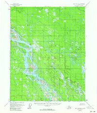
The braided channels of the Yukon River dominate this 1950s landscape, weaving through a dense network of sloughs and alluvial deposits within the Yukon Flats. This region is defined by its complex hydrology, where the Grass River and Sucker River meander through saturated lowlands typical of the interior Alaskan wilderness. Human presence is sparse and temporary, marked only by isolated Cabin sites and small clusters of Cabins along the water's edge, likely used for seasonal trapping or subsistence. Survey markers such as VABM Queen and VABM Halfway provide the few fixed reference points in this shifting environment of sandbars and oxbows. Notable landforms like Saloon Island appear amidst the river's split currents, illustrating the continuous process of erosion and sedimentation that reshapes the drainage basin of Squirrel Creek and its neighboring tributaries.
Find a feature on this map
9 named features on this map. Tap any name to fly to it.
Don’t see what you’re looking for? This feature index may not catch every label — zoom into the map to look around manually.
Map Details
Editions of this 1956 Fort Yukon B-2 Map
2 editions found
Other maps of this area

1951 · Fort Yukon
USGS Topo · 1:250,000

1952 · Fort Yukon C-2
USGS Topo · 1:63,360

1952 · Fort Yukon C-3
USGS Topo · 1:63,360

1955 · Fort Yukon C-3
USGS Topo · 1:63,360

1956 · Fort Yukon C-1
USGS Topo · 1:63,360

1956 · Fort Yukon A-2
USGS Topo · 1:63,360

1956 · Fort Yukon B-3
USGS Topo · 1:63,360

1956 · Fort Yukon B-1
USGS Topo · 1:63,360

1956 · Fort Yukon A-1
USGS Topo · 1:63,360
1956 · Fort Yukon A-3
USGS Topo · 1:63,360