
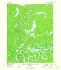
1952 Map of Fort Yukon C-2
USGS Topo · Published 1958About this map
Porcupine River and Black River define this complex aquatic landscape in the Alaska-Fourth Judicial Division, where a dense network of sloughs and oxbow lakes dominates the terrain. Based on 1952 aerial photography, the map reveals a wilderness where navigation relied entirely on these waterways. Isolated cabins are the only signs of human habitation, scattered along the banks of Steamboat Slough and near the junction of the Sheenjek River. The intricate drainage pattern, featuring named features like Old Man Lake and Box Car Slough, reflects a seasonal landscape defined by the shifting paths of the Sucker River and Grass River. This survey captures the region in its mid-century state, providing a precise record of water bodies such as Koduit Lake and Currant Lake before the impact of more modern topographical changes.
Find a feature on this map
18 named features on this map. Tap any name to fly to it.
Don’t see what you’re looking for? This feature index may not catch every label — zoom into the map to look around manually.
Map Details
Editions of this 1952 Fort Yukon C-2 Map
This is the sole edition of this map. No revisions or reprints were ever made.
Other maps of this area

1951 · Fort Yukon
USGS Topo · 1:250,000

1952 · Fort Yukon C-3
USGS Topo · 1:63,360

1955 · Fort Yukon D-2
USGS Topo · 1:63,360

1955 · Fort Yukon D-3
USGS Topo · 1:63,360

1955 · Fort Yukon C-3
USGS Topo · 1:63,360

1956 · Fort Yukon C-1
USGS Topo · 1:63,360

1956 · Fort Yukon B-3
USGS Topo · 1:63,360

1956 · Fort Yukon B-1
USGS Topo · 1:63,360

1956 · Fort Yukon B-2
USGS Topo · 1:63,360
1956 · Fort Yukon D-1
USGS Topo · 1:63,360