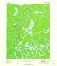
1956 Map of Fort Yukon D-1
USGS Topo · Published 1959About this map
Porcupine River and Sheenjek River dominate this interior Alaskan landscape, characterized by an intricate network of oxbow lakes, winding sloughs, and marshlands. Mapped in the mid-1950s using photogrammetric methods from 1955 aerial photography, the sheet records the complex hydrology of the Yukon Flats. The terrain is marked by notable bends and secondary waterways such as Curtis Slough and the uniquely named Bootleg Bend. Human presence is sparse, evidenced by isolated structures like Carls Cabin and another unnamed Cabin located near the riverbanks. This 1:63,360 scale survey provides a detailed look at the shifting channels of Ninemile Slough and Graveyard Slough before any modern infrastructure altered the natural drainage of these northern wetlands. Geodetic markers like VABM 492 Pork and VABM 486 Sheenjek serve as the primary navigational anchors in this water-rich environment.
Find a feature on this map
15 named features on this map. Tap any name to fly to it.
Don’t see what you’re looking for? This feature index may not catch every label — zoom into the map to look around manually.
Map Details
Editions of this 1956 Fort Yukon D-1 Map
3 editions found
Other maps of this area

1951 · Fort Yukon
USGS Topo · 1:250,000

1951 · Black River
USGS Topo · 1:250,000

1951 · Coleen
USGS Topo · 1:250,000

1951 · Christian
USGS Topo · 1:250,000

1952 · Fort Yukon C-2
USGS Topo · 1:63,360

1955 · Fort Yukon D-2
USGS Topo · 1:63,360

1956 · Coleen
USGS Topo · 1:250,000

1956 · Fort Yukon C-1
USGS Topo · 1:63,360

1956 · Black River D-6
USGS Topo · 1:63,360

1956 · Black River C-6
USGS Topo · 1:63,360